Tintagel Haven
The Beach Beneath the Castle - Home of Merlin's Cave
Tintagel Haven, Tintagel, Cornwall, PL34 0HE
Tintagel Haven is the small beach of sand, shingle and bare rock that sits directly beneath Tintagel Castle, hemmed in on both sides by the dark, contorted cliffs of one of Cornwall's most dramatic headlands. It is sometimes labelled Merlin's Cove or Castle Cove on maps and older guides, and it is not a beach anyone visits for a straightforward day on the sand - the sea covers most of it at high tide, the only reliable way down runs through the paid Tintagel Castle site, and its single best-known feature, Merlin's Cave, can only be entered for a few hours either side of low water. What makes the effort worthwhile is the combination on offer nowhere else in Cornwall: a working sea cave tunnelled clean through a headland, cliffs that record several hundred million years of geological upheaval, the ruins of a genuine early medieval stronghold overhead, and a legend - King Arthur's - that has been drawing visitors here since the Middle Ages.
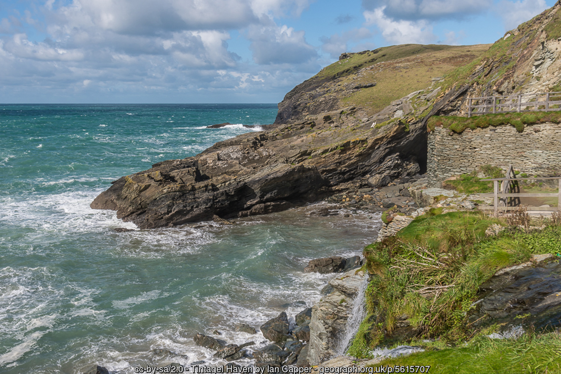
Merlin's Cave is the reason most people make the descent. It is a natural sea tunnel roughly 100 metres (330 feet) long, running clean through the base of the headland to link Tintagel Haven on the eastern side with a smaller cove, West Cove, on the western side. Geologists explain the tunnel as the product of marine erosion working along a thrust plane - a line of structural weakness between a band of slate and the volcanic rock beside it - so the sea has, over a very long time, hollowed out the weaker rock along that seam rather than cutting through solid cliff. At low tide you can walk through it on a floor of firm sand; as the tide rises the passage floods from both ends and becomes completely impassable, which is why every source of visitor advice for this beach comes back to the same instruction - check the tide table, and treat a rising tide as your cue to leave. In 2016 English Heritage commissioned stonemason Peter Graham to carve a sleeping face into the cliff at the cave's edge, popularly read as Merlin himself; it is a modern addition; and the cave's own name is younger than most visitors assume. No medieval account actually places Merlin in a cave here - the association only enters the written record in the late nineteenth century, encouraged by Alfred, Lord Tennyson's Arthurian cycle Idylls of the King and the wave of Victorian tourism that followed it. Archaeologists studying the wider site think the cove and its cave more plausibly served, in the fifth to seventh centuries AD, as a natural harbour where Mediterranean and Atlantic-facing traders unloaded fine pottery and other imported goods for the high-status settlement above - Tintagel's real early history is, if anything, stranger than its invented one.
The cliffs themselves are geologically well studied, forming part of a designated Geological Conservation Review site. They expose contorted Devonian and Lower Carboniferous slates interleaved with bands of altered volcanic rock, including pillow lava - lava that erupted from vents on the sea floor and cooled almost instantly into rounded, pillow-shaped lobes as it met cold water. Tens of millions of years after that volcanism, the entire sequence was folded, faulted and in places turned completely upside down during the Variscan mountain-building episode that also raised Bodmin Moor and Dartmoor, leaving the layered, crumpled rock visible in the cliff faces today. That same slate had a working life within human memory: Tintagel's cliffs were quarried for roofing slate well into the modern era, hauled down from clifftop workings by wooden derricks whose remains can still be seen above the beach, and shipped out through exactly this kind of exposed, rock-strewn cove using a technique called "hobbling", where rowing boats towed the waiting vessel and its crew hauled on ropes to hold position clear of the rocks while cargo was loaded. An 1818 sketch by J.M.W. Turner records derricks working above this coastline, loading slate for export and, on the return journey, bringing Welsh coal back in.
Tintagel's connection to King Arthur is the older and much better-known story, and it begins with a specific text rather than folk memory: Geoffrey of Monmouth's twelfth-century Historia Regum Britanniae, which places Arthur's conception at "Tintagol" through Merlin's magic, disguising Uther Pendragon as the Duke of Cornwall so he could reach Ygerna within the fortress walls. There is no evidence this legend has any basis in real events, and no medieval source connects it to the cave beneath the castle specifically - but the story stuck fast to this headland, was revived enthusiastically by the Victorians, and now shapes almost everything about how the site is presented, down to the footbridge that has spanned the gap between the mainland and the island portion of the castle since 2019, replacing a set of precarious steps and improving access to the beach steps beyond it. The most recent addition to the legend is physical rather than literary: Gallos, an eight-foot bronze figure by sculptor Rubin Eynon installed on the island headland above the beach in 2016. Its name is the Cornish word for "power", and English Heritage is careful to note it does not depict Arthur, or any single historical person - deliberate gaps left in the bronze let the sea and sky show through, and the figure is meant to evoke Tintagel's real documented past as a probable seasonal residence of the early medieval kings of Dumnonia as much as its invented Arthurian one.
None of this history changes the plain physical fact that governs a visit: Tintagel Haven is a tidal beach in the strictest sense. The sand and shingle that appear at low water are substantially covered by high tide, and both the beach and Merlin's Cave should be treated as accessible only within a falling-to-low tide window, checked in advance rather than assumed. There is no lifeguard service here, currents and swell can build quickly around the cave's twin mouths, and the steps down - whether the main flight within the Castle site or the rougher, unmaintained scramble sometimes used from the mainland cliff path - are steep, uneven in wet weather, and unsuitable for pushchairs or anyone unsteady on their feet. Given the choice, most visitors will find it easier and no less rewarding to reach the beach via the Castle's own route, allowing time for both the walk from the village car parks and the climb back up afterwards.
Once the tide allows it, the cove rewards a slow look rather than a swim. The beach itself is a mix of sand, shingle and pebbles that gives way to bare, ridged rock and productive pools as the tide drops further, and a small stream draining the valley behind the village adds an informal waterfall onto the sand after rain, tumbling down near the cave mouth. Grey seals are regularly reported in the water offshore, and the sheer, undercut cliffs on both sides of the cove - like much of this stretch of Heritage Coast - provide nesting ledges used by fulmars and other seabirds through spring and summer. Wading and rockpooling in the shallows on a calm, settled low tide are the safest ways to enjoy the water here; open swimming is not recommended.
Above the beach, Tintagel village (still occasionally called by its older name, Trevena) has built its identity almost entirely around the castle and its legend since Victorian tourism first discovered the place, and Fore Street still carries the shops, cafes, pubs and the National Trust's Old Post Office among the newer Arthurian-themed trade. Walkers based here are well placed for both directions of the South West Coast Path - north past Barras Nose towards Bossiney and Rocky Valley, or south towards Trebarwith Strand and Backways Cove - and for a look back at the castle and cove from the clifftop even on a day when the tide keeps the beach itself out of reach. Because access depends so heavily on the tide, the quieter, cooler months either side of summer, combined with a calm forecast and a falling tide timed for the early or late part of the day, tend to give the most comfortable and least crowded visit; a busy midsummer low tide at the height of the school holidays can mean a genuine queue for the steps.
Visitor Information
Parking
No parking at the beach. Nearest is pay-and-display in Tintagel village, around 600m from the Castle entrance, plus the walk and steps down to the cove.
Facilities
None at the beach itself. Toilets, a café and a shop are at the Tintagel Castle visitor centre; more cafes, pubs and shops are in the village on Fore Street.
Disabled Access
Not accessible - reaching the beach involves steep cliff steps within the Castle site, plus a footbridge to the island section. Unsuitable for wheelchairs or pushchairs. No Blue Badge parking or access provision at the cove itself - the steps down are steep and uneven throughout.
Things to Do Nearby
- Bossiney Cove, a short walk or drive north
- Trebarwith Strand, a short drive south
- Tintagel Castle (English Heritage) - the site the beach sits beneath
- Tintagel Village Guide - shops, cafes and the village itself
- South West Coast Path Guide - walking routes along this stretch of coast
Places to Stay
Frequently Asked Questions
Page last updated: 8 September 2026.