Millook
A Tiny Cove World-Famous for its Zigzag Chevron-Folded Cliffs
Millook (Millook Haven), near Bude, Cornwall, EX23 0DQ
Millook, often written as Millook Haven, is one of the smallest and least developed beaches on the whole of Cornwall's north coast - a narrow pebble cove tucked into a fold of the Heritage Coast roughly midway between Widemouth Bay to the north and Crackington Haven to the south, in the parish of Poundstock. It has no car park, no cafe, no shop and no lifeguard, and most visitors who are simply looking for an easy family beach day would do better a couple of miles in either direction. What Millook does have, and what draws a steady stream of geologists, students and photographers from across the country and beyond, is one of the most dramatic and photographed examples of folded rock strata anywhere in Britain: a sweep of tightly zigzagging, chevron-patterned cliffs that has made this obscure little valley a genuine site of scientific pilgrimage.
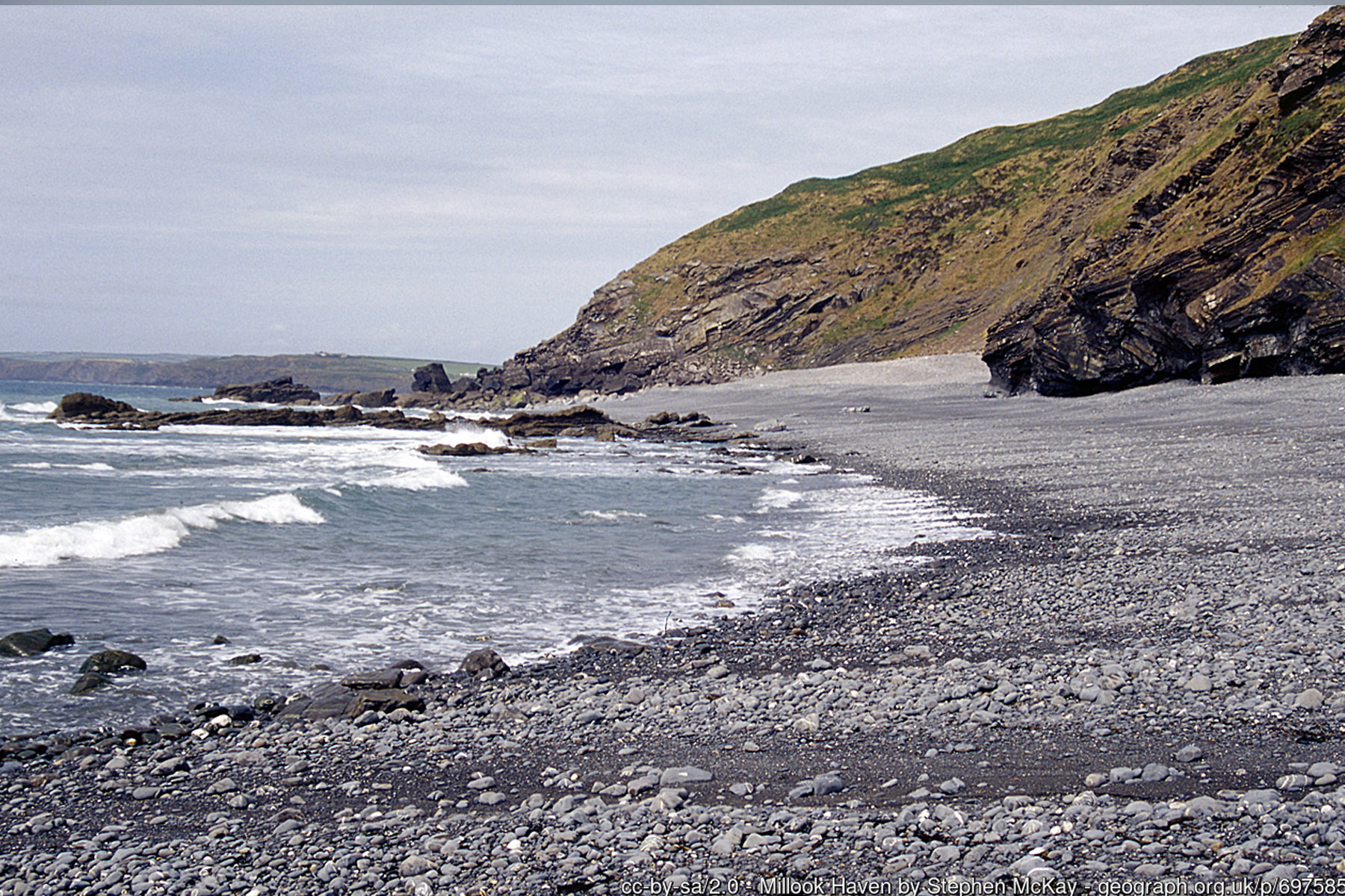
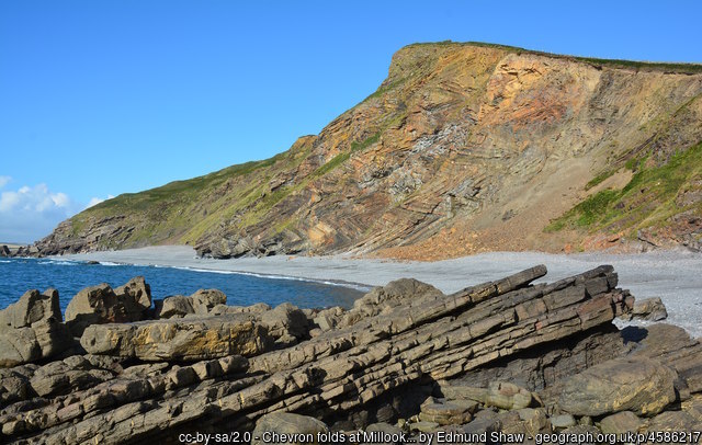
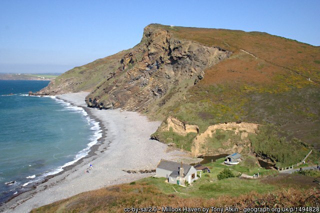
The cliffs on the northern side of the cove are the reason Millook appears in geology textbooks and field-trip itineraries worldwide. Here, thinly bedded layers of sandstone and shale - originally flat sheets of sand and mud laid down on the floor of a deep ocean basin by submarine turbidity currents, roughly 300 million years ago in the Late Carboniferous period - have been folded into an extraordinary, repeating zigzag pattern known as chevron folding. Rather than bending in smooth, rounded waves, the alternating hard and soft rock layers buckled sharply at a series of tight, angular hinges, producing the classic accordion-pleat profile visible in the cliff face today. The Geological Society of London includes Millook Haven among its list of Great Britain's finest geological sites in the folding-and-faulting category, and specialist sources routinely describe it as one of the best - if not the single best - exposed examples of chevron folding anywhere in the United Kingdom.
These folds are part of the wider Crackington Formation, a thick sequence of Carboniferous turbidite sandstones and mudstones that runs along much of this stretch of coast towards Bude and on into Devon, and they were thrown up during the Variscan orogeny - the same enormous continental collision, as ancient landmasses that would become Europe and North Africa were pushed together, that built mountain ranges across much of southern Britain and continental Europe around 300 million years ago.
The compressive forces of that collision squeezed and crumpled the layered rocks of the Millook valley into their present zigzag form, with individual fold limbs running for many metres and hinges so sharp and regular that they look almost too precise to be natural. Geology field trips from universities across the UK and further afield visit Millook specifically to study the folds at close range, and the outcrop is frequently used in textbooks and lecture slides as a textbook illustration of chevron folding in action.
Away from the geology, Millook itself is a modest, low-key cove. The beach is composed mainly of large pebbles and coarse shingle, with substantial areas of bare rock exposed for much of the tidal cycle; a certain amount of sand appears between the rocks as the tide drops, but this is not a sand beach in the way Widemouth Bay or Summerleaze are, and it is not designated as a bathing beach. The cove faces north-west and sits beneath the imposing bulk of Penhalt Cliff, which shelters it a little from the prevailing south-westerly wind but does nothing to soften the swell that rolls in off the open Atlantic. That swell, combined with a reef-like sea bed of folded rock, makes Millook a well-known - if serious - spot among experienced surfers, but it is not a place for beginners or for casual sea swimming; submerged rock ledges, changeable currents and the total absence of any lifeguard cover mean the water here should be treated with real respect.
Access to Millook is part of its character and, for many visitors, part of its appeal. The lane down from the A39 at Wainhouse Corner drops steeply into the valley in a series of tight bends, including one notably sharp hairpin that larger vehicles can struggle with, before levelling out just above the beach itself. There is no formal car park: parking amounts to a small informal layby and a handful of roadside spaces on the hill, enough for only a few cars at a time, plus a slightly larger layby a little further up the lane for those happy to walk the final stretch down. Space disappears quickly on a sunny day, particularly in summer, and there is no realistic overflow option nearby, so an early start or an out-of-season visit is the more reliable way to see the cove without a long wait or a walk back up from Widemouth Bay along the coast path instead.
Facilities at Millook are non-existent - no toilets, no shop, no cafe, no bins - so anyone planning to stay for a while should bring water, food and anything else they might need, and take all litter away with them. The nearest facilities of any kind are at Widemouth Bay, a couple of miles north, or Crackington Haven, a little further south, both of which have cafes, toilets and seasonal RNLI lifeguard cover that Millook itself does not. Mobile phone signal in the valley is patchy at best, which is worth bearing in mind given the steep access and lack of any on-site supervision. Dogs are welcome at Millook all year round, with none of the seasonal summer restrictions that apply on the bigger, more commercialised beaches closer to Bude - a point in its favour for dog walkers looking for a quieter alternative.
The wooded valley running inland from the cove is also of note in its own right: a substantial area of ancient semi-natural woodland lines the stream that runs down to the beach, part of the Cornwall Area of Outstanding Natural Beauty and considered by conservationists to be among the best surviving ravine woodland in the county. The South West Coast Path runs along the cliff top directly above Millook, linking it on foot to Widemouth Bay to the north and to Dizzard Point, Chapman's Point and Crackington Haven to the south, and this section is rated as one of the more strenuous but rewarding stretches of the path in north Cornwall, with a succession of steep valleys, or "chines," to climb in and out of. Walkers tackling the coast path between Bude and Boscastle typically pass directly above the chevron folds without a detour required, making Millook an easy, worthwhile stop to build into a longer walking day even for those not planning to visit the beach itself.
Because it offers so little in the way of conventional beach amenities, Millook rewards a particular kind of visitor rather than a crowd: geology enthusiasts and students there for the folds, coast path walkers passing through, photographers drawn by the graphic pattern of the rock and the light on the water, and experienced surfers seeking an uncrowded, exposed break away from the busier beaches nearby. Low tide is the best time to appreciate both the geology and the beach itself, exposing more of the folded rock platform and the small sandy patches between the boulders, while a falling tide on a calm, clear day gives the sharpest view of the zigzag cliff face for photography. Whatever the reason for the visit, Millook is best approached as a short, specific detour rather than a full day out - a striking contrast to its larger, better-equipped neighbours, and one of the more genuinely distinctive small coves anywhere on the Cornish coast.
Visitor Information
Parking
No car park. Very limited informal roadside/layby parking on the steep hill lane down into the valley - space for only a handful of cars.
Facilities
None on site - no toilets, shop or cafe. No lifeguard cover at any time of year. Nearest facilities are at Widemouth Bay or Crackington Haven.
Disabled Access
Not wheelchair accessible - the lane down is steep, and the beach surface itself is pebble, shingle and exposed rock. No dedicated Blue Badge provision - parking is informal roadside space only, on a steep hill lane.
Things to Do Nearby
- Widemouth Bay, a couple of miles north, for sand, facilities and seasonal lifeguard cover
- Crackington Haven, a scenic drive or coast path walk south
- Bude Surf Beaches Map & Complete Surf Guide - other surf spots near Millook
- South West Coast Path Guide - the strenuous, scenic Widemouth Bay to Crackington Haven section passes directly above Millook's chevron folds
Places to Stay
Frequently Asked Questions
Page last updated: 7 September 2026.