Port Quin
A Tiny, Near-Deserted Hamlet on a Quiet Rocky Inlet
Port Quin, near Port Isaac, Cornwall, PL29 3SU
Port Quin is one of the smallest and quietest places on the whole of Cornwall's north coast - so small that it barely counts as a village at all. A handful of stone cottages sit gathered around a narrow, steep-sided inlet between Port Isaac and Polzeath, and there is no sandy beach here: at low tide the inlet floor is rock, shingle and pool, framed by a small stone harbour and slipway that once served a working fishing community. What draws visitors today is not a day on the sand but the setting itself - a genuinely undeveloped stretch of the South West Coast Path, a real (if partly legendary) history, and a sense of stillness that is increasingly rare on this coastline in summer.
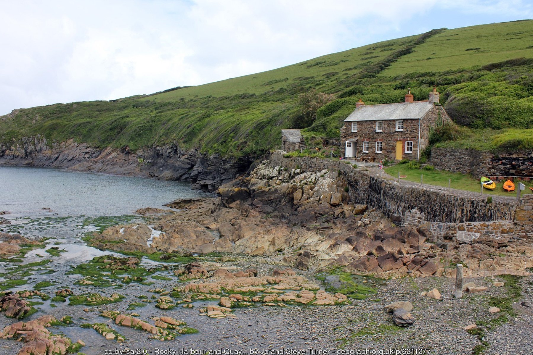
The name is thought to derive from the Cornish Porth Gwynn, "white cove". The earliest documented reference dates to 1327, when a Laurence de Porquin is recorded taking his name from the settlement, and for centuries afterwards Port Quin functioned as a genuine working harbour, however modest - small coastal vessels traded coal, manure, antimony and lead ore out of the inlet, and granite shipped in from Lundy Island was landed here to help build the tower of the parish church at nearby St Endellion. Pilchard fishing, worked each year through the late-summer and autumn season, was the mainstay of the local economy for generations, and the size of the fish cellars still standing above the old slipway - since converted into holiday cottages - gives some sense of how much larger and more prosperous a settlement this once was. The 1841 census recorded around 94 people living here across 23 houses; within fifty years the population had fallen to barely 20.
The storm legend, and why it should be treated carefully: Port Quin's abrupt decline has given rise to one of north Cornwall's best-known pieces of coastal folklore - that the entire male population of the village put to sea one day and never returned, drowned together in a single catastrophic storm, leaving the settlement populated only by widows who eventually had no choice but to leave. Some versions add that the disaster struck on a Sunday, framed as divine punishment for fishing on the Sabbath; others drop the storm and describe the men lost in one boat rather than a whole fleet; the number of widows said to have been left behind varies between tellings, and one version of the story is often linked to Frank Bramley's 1888 painting A Hopeless Dawn, now in the Tate. It is a genuinely evocative story, but researchers who have looked for it in the historical record have found no contemporary account of any such disaster - no newspaper report at the time, no cluster of burial entries in the parish register - with the tale seemingly only appearing in print decades later, in the 1890s. The census evidence points instead to a slower, more mundane decline: as the pilchard fishery failed and nearby Port Isaac's better-sheltered harbour drew trade away during the first half of the 19th century, families gradually left for work elsewhere, some emigrating to Canada via Padstow. The legend endures because it is a powerful story, but it is best presented to visitors as folklore rather than settled fact.
The most eye-catching building at Port Quin is Doyden Castle, a small castellated folly built around 1830 on Doyden Point, the headland forming the western side of the inlet, reputedly commissioned by a wealthy Wadebridge gentleman, Samuel Symons, as a retreat for entertaining and gambling with friends rather than as any kind of genuine fortification. It is now let by the National Trust as a holiday cottage for two, and its dramatic clifftop position has made it a repeat filming location, standing in as a gatehouse in the 1970s television adaptation of Poldark and appearing again in the 1983 film of Jamaica Inn and, decades later, in the ITV drama Doc Martin. A short distance inland, Doyden House - built in the early 20th century as a retirement home for a former prison governor - is also let today as holiday accommodation, though it is a private letting rather than a National Trust one.
The valley's mining past is easy to overlook but genuinely part of the landscape: Port Quin Mine once worked antimony close to the inlet, and Gilson's Cove Mine, a short walk along the coast, produced lead and silver-lead ore, its old workings including a horse-powered whim for hauling material up the shaft. Both mines have long been disused, and open shafts near the coast path are fenced with the traditional slate-post barriers used across Cornwall's old mining ground - a reminder to keep dogs and children close and stay on the marked paths in this area.
Geologically, Port Quin sits within the same folded sequence of shales, slates and sandstones that shapes this entire stretch of the north Cornwall Heritage Coast between Bude and Padstow, laid down as marine sediment around 300 million years ago and later crumpled and tilted by the earth movements that built much of south-west Britain's coastal scenery. The narrow inlet itself has been cut along a natural line of geological weakness in this folded rock, which is exactly why it forms such a sheltered, steep-sided natural harbour rather than an open bay. There is no sand to speak of - only bedrock, loose shingle and boulders, uncovered progressively as the tide falls - but that same rocky floor makes for good, quiet rockpooling well away from the crowds of the bigger holiday beaches nearby, and the clear water in the deeper parts of the inlet is popular with snorkellers and sea kayakers on calm days.
Almost the whole hamlet and a wide swathe of the surrounding clifftop farmland belong to the National Trust, which manages the land as part of its long-running coastal conservation work along this section of coast, including an ongoing project to restore species-rich coastal grassland and meadow across several hundred hectares of the wider area. Several of the old stone fishermen's cottages in the hamlet are let by the Trust as self-catering holiday accommodation - among them Quin Cottage, Guy's Cottage, Lacombe Cottage and Carolina Cellar, the last a converted historic pilchard cellar - alongside Doyden Castle itself on the headland above. Staying in one of these cottages is, realistically, the closest most visitors will get to experiencing Port Quin's old fishing-village character first-hand, since there is so little else left standing from that era.
The cliffs and headlands either side of the inlet support a typical, and genuinely rewarding, north Cornwall seabird population - fulmars, guillemots and razorbills nest on the rock ledges in season, while wildflowers such as thrift and spring squill colour the clifftop grass. Grey seals and, more occasionally, dolphins are seen off this stretch of coast, as they are along much of north Cornwall, though sightings at Port Quin itself are a matter of luck rather than a guaranteed feature of a visit.
Port Quin sits directly on the South West Coast Path, and this is really the point of the place for most visitors: a network of quiet, well-marked walking routes rather than a single big attraction. To the east, the path climbs past Kellan Head towards Varley Head and on to Port Isaac and Port Gaverne, around two miles away, passing some of the most dramatic and least-visited cliff scenery on this coast. To the west and south, it rounds Doyden Point and continues via Pentireglaze Haven and Lundy Bay towards The Rumps - a distinctive double-headed promontory fort site - and on to Pentire Head and Polzeath beyond, one of the most celebrated short stretches of coastal walking in Cornwall. The National Trust has waymarked several shorter circular routes based at Port Quin itself, ranging from around a mile up to roughly three and three-quarter miles, making it easy to tailor a walk to the time and energy available rather than committing to the full coast path in either direction.
There genuinely is no shop, cafe or pub in Port Quin itself, and this should be taken at face value rather than treated as an oversight in this guide - it is precisely what keeps the hamlet as quiet as it is. A small seasonal drinks-and-snacks stand has operated near the car park in recent summers, roughly April to October, but it is not part of the National Trust's own offering and should not be relied upon outside the summer season. The nearest proper facilities - shops, pubs, cafes and toilets - are in Port Isaac, a short drive away or a longer, more scenic walk along the coast path. Given the total absence of facilities, no lifeguard cover, and a car park with steep, uneven surfaces and no dedicated disabled access, Port Quin suits a considered, well-prepared visit - bring what you need, take your litter home, and treat the inlet itself with the same care as any unsupervised rocky Cornish shoreline, particularly around the mine workings above the cliffs.
Visitor Information
Parking
Small National Trust car park with a gravel surface. Free for National Trust members; charges apply for other visitors.
Facilities
No permanent shop, cafe or toilets. A seasonal (non-NT) drinks and snack stand has operated April-October in recent years. Nearest full facilities are in Port Isaac.
Disabled Access
Not accessible - steps, steep slopes and uneven surfaces throughout, with no step-free route to the shore. No dedicated Blue Badge bays in the car park, and no accessible route down to the inlet itself.
Things to Do Nearby
- Port Isaac, around two miles east along the coast path, or a short drive
- Port Gaverne, a quiet pebble cove just beyond Port Isaac
- Port Isaac, Port Quin & Port Gaverne Guide - shops, cafes and the wider village
- Polzeath Village Guide - reached via Doyden Point, The Rumps and Pentire Head
- South West Coast Path Guide - walking routes along this stretch of coast
Places to Stay
- Doyden Castle - National Trust holiday cottage on the headland above Port Quin
- Quin Cottage and other National Trust cottages in the hamlet itself
- Self-catering cottages in Port Isaac
- Holiday accommodation in Port Isaac
Frequently Asked Questions
Page last updated: 8 September 2026.