Boscastle Harbour Beach
A Small Tidal Beach in a Historic Working Harbour
Boscastle Harbour, Boscastle, Cornwall, PL35 0HD
Boscastle Harbour Beach is best understood before you arrive: it is not a stretch of open sand but the small shingle-and-boulder foreshore that appears in and around the mouth of Boscastle's historic harbour as the tide falls, on one of the most dramatic and tightly enclosed stretches of the whole North Cornwall coast. What draws people here is not sunbathing but the setting itself - a narrow, dog-legged natural harbour squeezed between towering slate cliffs, working boats still moored inside it, a genuine blowhole thumping away at the harbour mouth, rockpools among the boulders, and two of the finest sections of the South West Coast Path leading off in either direction. Boscastle rewards a slower, more curious kind of visit than a typical beach day, and this page sets out what is actually here, when to see it at its best, and what to be careful of.
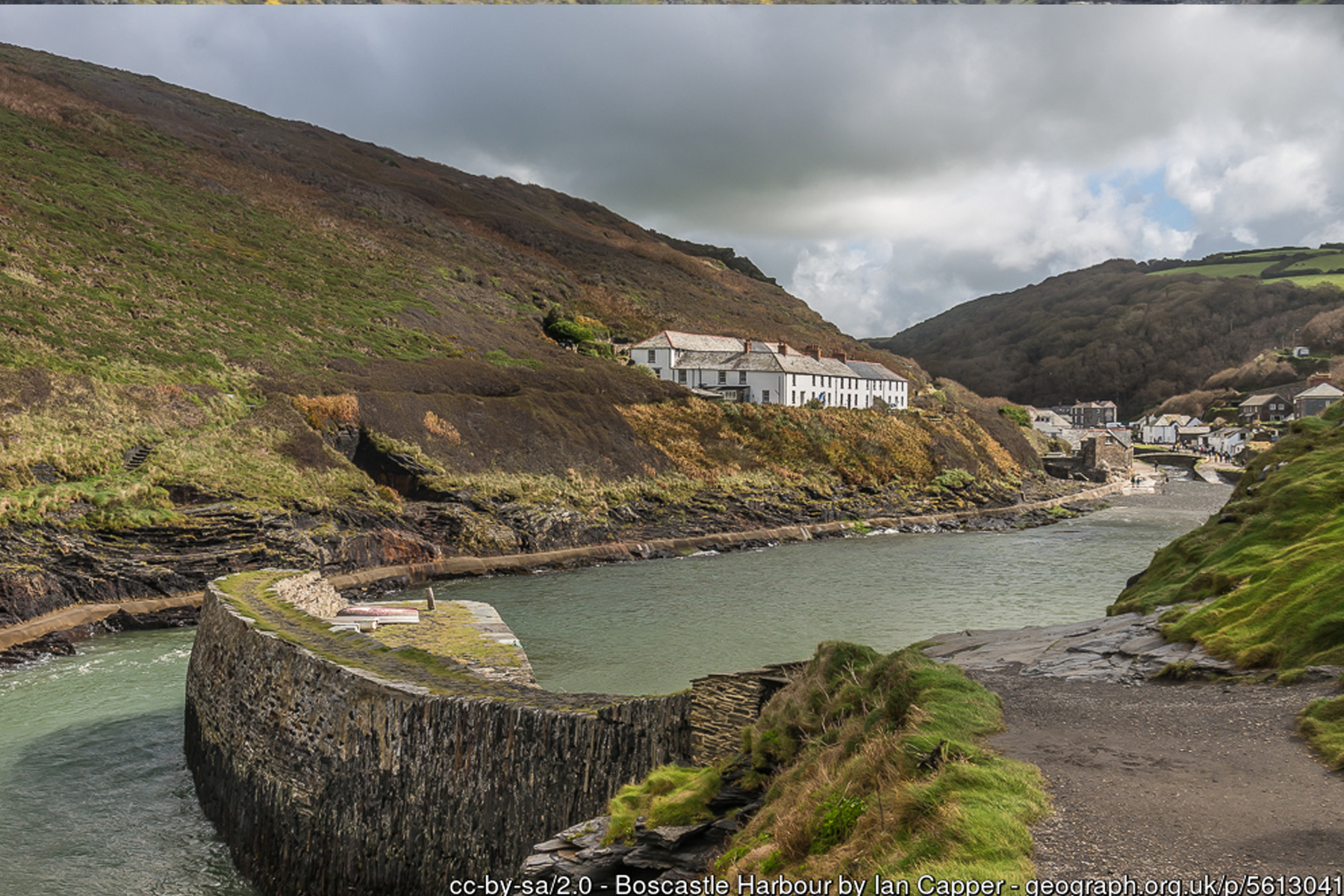
The harbour itself is genuinely historic. Documentary evidence shows a pier already existed at Boscastle by 1547, with parish contributions recorded towards quay repairs in 1549, but the structure visitors see the clearest trace of today dates from around 1584, when Sir Richard Grenville - the Elizabethan naval commander and Cornish landowner later famous for his last stand aboard the Revenge - commissioned detailed plans recording the wages and dimensions of the harbour walls being built. For most of the following three centuries Boscastle mattered enormously to this coastline for one simple reason: for around forty miles of exposed, cliff-bound Cornish coast between the Camel estuary and Bude, it was the only place a vessel of any size could find safe shelter. Ketches and schooners worked cargo in and out of the narrow entrance carrying coal, limestone, wine and pottery from South Wales, Bristol and further afield, and taking away Cornish corn, roof slate, tanning bark, and, in the nineteenth century, manganese ore and china clay. An 1861 account of the harbour describes a working quayside crowded with warehouses, workshops, shipyards and timber yards - a far cry from the quiet scene most visitors see today. That trade declined sharply once the railway reached nearby Camelford in 1893, after which road transport gradually took over and the harbour's commercial life faded, leaving fishing and, eventually, tourism as its mainstays.
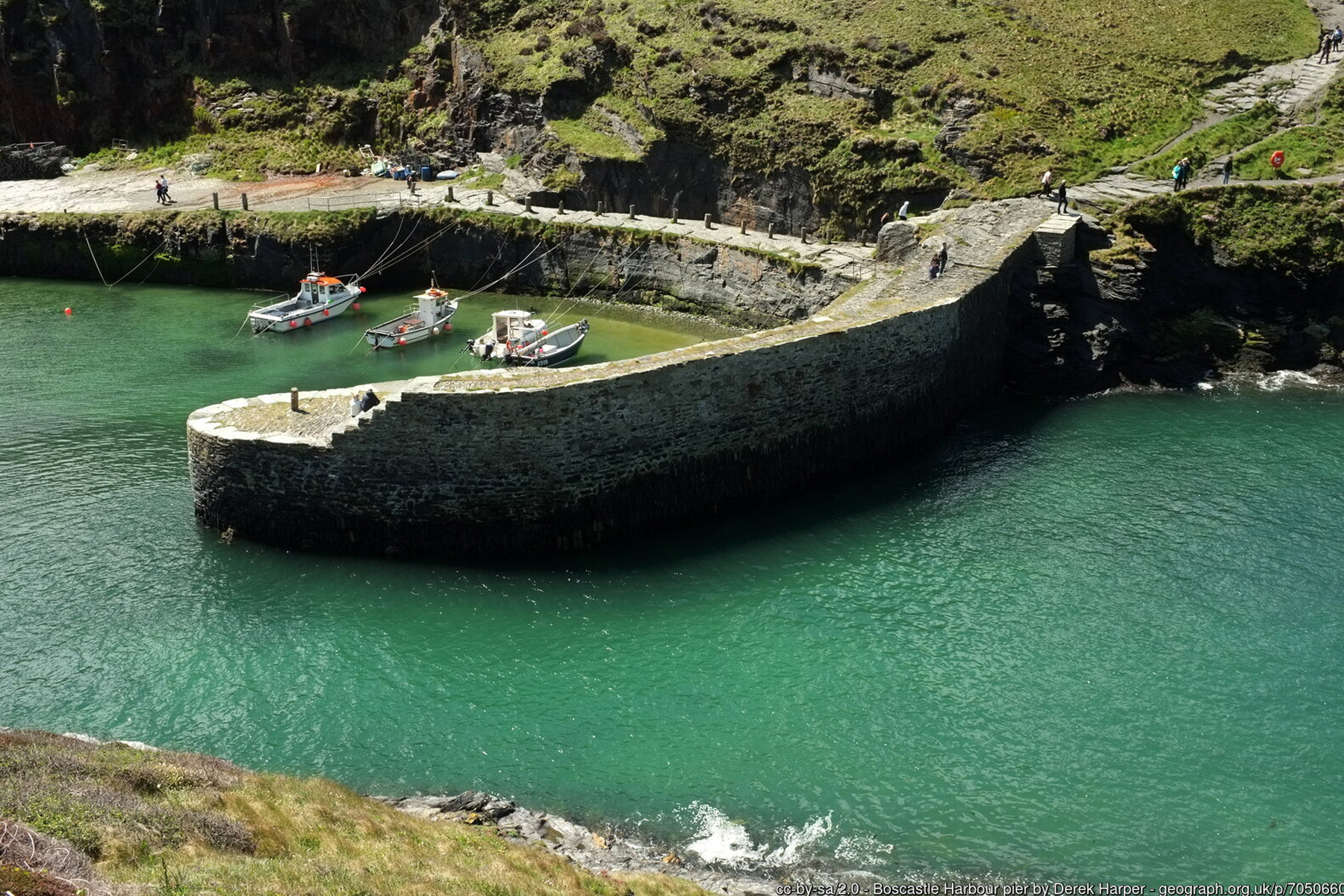
The harbour's famous shape - a narrow, right-angled "dog-leg" entrance rather than a straight channel to the sea - is not an accident of engineering but of geography: it is the only point on this whole stretch of coast where a natural inlet in the cliffs allowed a harbour to be built at all, and the sharp bend in the channel has always helped absorb the worst of the Atlantic swell before it reaches boats moored inside. The southern harbour wall, still substantially the structure recorded in Grenville's 1584 plans and built from local slate rubble bonded with quartz, is a listed structure in its own right. The outer breakwater, added in the early nineteenth century to give still more shelter, had a harder twentieth century: it was destroyed in 1941 when a mine drifted into the harbour during the Second World War, and was not rebuilt until 1962, using stone salvaged from the recently demolished Laira Bridge in Plymouth - a nice piece of maritime recycling. The National Trust, which owns and manages both sides of the harbour and much of the surrounding coastline and countryside today, has maintained these structures ever since.
No account of modern Boscastle is complete without the flood of 16 August 2004, one of the most severe flash floods recorded in British history. Following days of already-saturated ground, an intense, slow-moving thunderstorm dropped extraordinary amounts of rain onto the small Valency and Jordan river catchments above the village within a couple of hours - Boscastle itself recorded around 89mm of rain in just sixty minutes, with even higher short-burst intensities nearby. The rivers, funnelled by the valley's steep sides, rose with almost no warning; witnesses described a wall of water surging through the village. Around a hundred cars, several caravans and boats, and a number of buildings were swept down into the harbour, homes and businesses were wrecked, and multiple bridges were destroyed. Remarkably, despite the scale of the destruction, no one died: roughly 150 people were plucked from rooftops, trees and marooned vehicles by a fleet of Sea King helicopters flown in from RAF Chivenor, RNAS Culdrose, RAF St Mawgan and the coastguard base at Portland, working from mid-afternoon into the small hours. The worst reported injury was a broken thumb. In the years since, the river channel through the village has been substantially widened and lowered, new pumping stations, overflow culverts and a raised car park level installed, and the harbour bridge rebuilt, as part of a flood alleviation scheme completed later in the decade - engineering that both protects the rebuilt village and, together with the National Trust's ownership of the harbour, keeps this place looking much as it always has to a visitor standing at the water's edge today.
Down at the harbour mouth itself, the "beach" proper only really appears as the tide drops, exposing shingle, boulders and slate ledges around the piers and along the base of the cliffs. This is prime rockpooling ground for anyone willing to pick a careful path over wet rock - shore crabs, anemones, blennies and the usual rich variety of a sheltered, rocky Cornish shoreline can all be found among the pools, and the harbour walls themselves are frequently draped with seaweed and barnacles that reward a closer look. Tucked into the rocks close to the harbour entrance, opposite the blowhole, is a disused Victorian tidal bathing pool, built originally for local swimmers together with the remains of old shellfish storage tanks nearby. It is no longer officially maintained - recent visitors report the pool itself now holds only a shallow covering of water after storm damage - and the worn stone steps down to it have no handrail and become treacherous when wet, so this is a spot for confident, experienced scramblers around low tide only, not families or dog walkers.
The other unmissable natural feature here is the blowhole at Penally Point, on the northern side of the harbour mouth, known locally as the Devil's Bellows. For roughly an hour either side of low tide, air and spray forced through a fissure in the slate produce a distinctive thumping, snorting roar, and in the right swell conditions it can throw spray - occasionally even a jet of water - clean across the harbour entrance. It is a genuinely striking thing to witness and one of the main reasons to time a visit to Boscastle around low water rather than high. The slate and sandstone cliffs that frame all of this belong to the same folded Carboniferous "Culm" sequence found along the whole Bude-to-Boscastle coast; geologists have documented repeated, complex folding in the rock exposed around Boscastle itself, part of the same intense crumpling of the earth's crust, around 300 million years ago, that produces the far more famous zigzag chevron folds a few miles south at Millook. Slate was quarried from the cliffs either side of the harbour well into the twentieth century, and old quarry workings are still visible from the coast path.
Wildlife is easy to spot around the harbour and the cliffs either side of it. Fulmars, guillemots and razorbills nest on the ledges in season, grey seals are regularly seen hauled out on rocks near the harbour mouth or bobbing offshore, and the clifftop fields grazed by cattle and ponies as part of the National Trust's conservation grazing scheme mean dog walkers should stay alert and keep dogs under close control on the approach paths. The harbour is also a working anchorage for small boats and, in season, kayaks and canoes, all of which pay a small harbour fee to the Trust - worth bearing in mind when swimming or scrambling near the entrance, since this is not exclusively pedestrian space.
Two of the best sections of the South West Coast Path in Cornwall lead straight out of the harbour. Heading north-east, the path climbs steeply over Penally Point and along an exposed clifftop to Pentargon, a dramatic hanging-valley cove roughly a mile away where a waterfall drops around 36 metres to the shore - reachable only on foot, and covered in full on Pentargon's own page. Heading the other way, south-west out of the village, the path climbs Willapark headland, a 96-metre (317ft) promontory crowned by an Iron Age hillfort - its single defensive bank, thought to date from around 200BC, still visible across the neck of the headland - and by a whitewashed Victorian lookout tower, originally a merchant's pleasure house, later a Board of Trade coastguard station for around a century, and now run as a lookout by the National Coastwatch Institution. Beyond Willapark the coast path continues on towards Rocky Valley and Bossiney Cove, covered on this site's Bossiney Cove page, and eventually Tintagel.
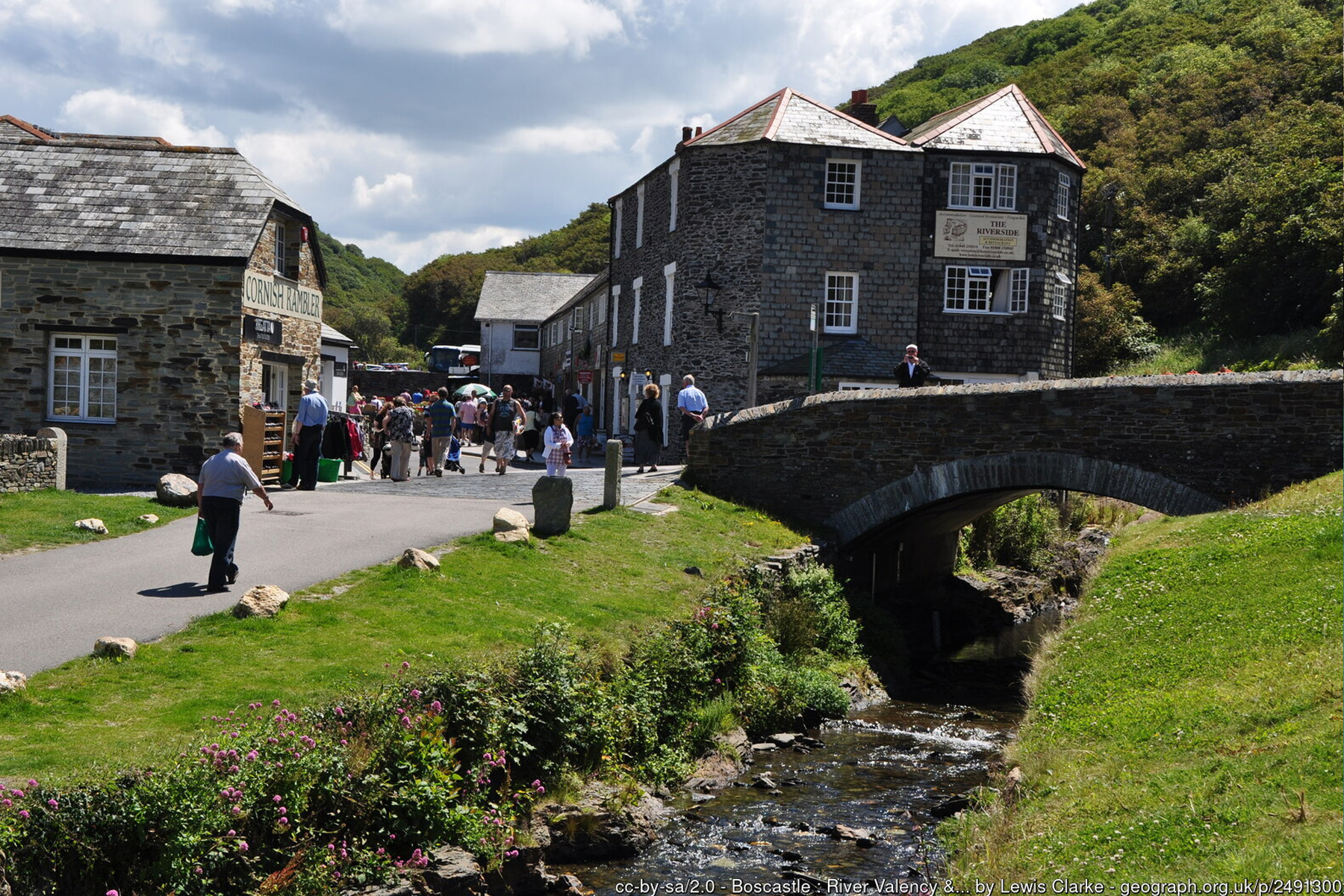
Boscastle village itself, a short and level walk from the harbour, is worth building time into any visit around. It is home to the Museum of Witchcraft and Magic, founded by Cecil Williamson in 1951 and based in Boscastle since 1960, which holds what is widely described as the world's largest collection of objects relating to witchcraft, folk magic and ritual practice - a genuinely unusual and popular attraction for a small Cornish harbour village. The National Trust runs a shop and café on the harbourside itself, and the wider village has independent shops, pubs and cafes to explore, alongside the blacksmith's forge and lime kiln that survive as physical reminders of the harbour's working past. The Valency Valley behind the village has its own literary footnote: the novelist and poet Thomas Hardy, then a young architect, visited in 1870 to oversee restoration work at St Juliot's church nearby, and met Emma Gifford, who became his first wife - an episode that later coloured some of his poetry about this stretch of coast.
Put simply, Boscastle Harbour Beach is a place to explore rather than a beach to spend a whole day lying on. Come around low tide for the best rockpooling, the exposed foreshore and the blowhole in full voice; keep a close eye on children and dogs near the harbour walls, the blowhole and the old tidal pool steps, all of which involve wet rock, unfenced drops or a lack of handrails; and treat the coast path in either direction as a proper, sometimes strenuous walk rather than a stroll. There is no lifeguard cover at any point around the harbour, and this is not a conventional swimming beach - but for scenery, history and sheer atmosphere, few small beaches in Cornwall pack in as much.
Visitor Information
Parking
National Trust pay-and-display car park a short, level walk from the harbour - also the main parking for the village and coast path.
Facilities
National Trust shop and cafe at the harbour, public toilets near the car park, and village shops, pubs and cafes a short walk away.
Disabled Access
The main harbourside path from the car park is relatively flat and partly paved, but the rocky foreshore, blowhole rocks and old tidal pool steps are not wheelchair or pushchair accessible. Blue Badge parking is available at the harbour car park - check current bay provision with the National Trust on arrival, as it is a small village car park.
Things to Do Nearby
- Pentargon, a dramatic waterfall cove a mile up the coast path to the north-east
- Bossiney Cove, reached via the coast path south-west over Willapark headland
- Boscastle Village Guide - the Museum of Witchcraft and Magic, shops, cafes and the village itself
- South West Coast Path Guide - walking routes along this stretch of coast
Places to Stay
Frequently Asked Questions
Page last updated: 8 September 2026.