Pendower Beach
A Vast National Trust Beach Linked to Carne at Low Tide
Pendower Beach, Roseland Peninsula, Cornwall, TR2
Pendower Beach is one of the largest and most open stretches of sand on the whole of the Roseland Peninsula, running along the western shore of Gerrans Bay on Cornwall's gentler, south-facing coast. Owned and managed by the National Trust, it sits behind a broad belt of dunes with a generous car park set back from the shore, and at low tide it does something few Cornish beaches can claim: it joins seamlessly with neighbouring Carne Beach to the east, the two together forming a single unbroken sweep of sand stretching for well over a mile across the bay. For a peninsula better known for its tucked-away coves and tidal creeks, Pendower's scale comes as something of a surprise, and it is precisely that combination of space, easy access and genuine National Trust countryside that has made it one of the Roseland's most popular family beaches.
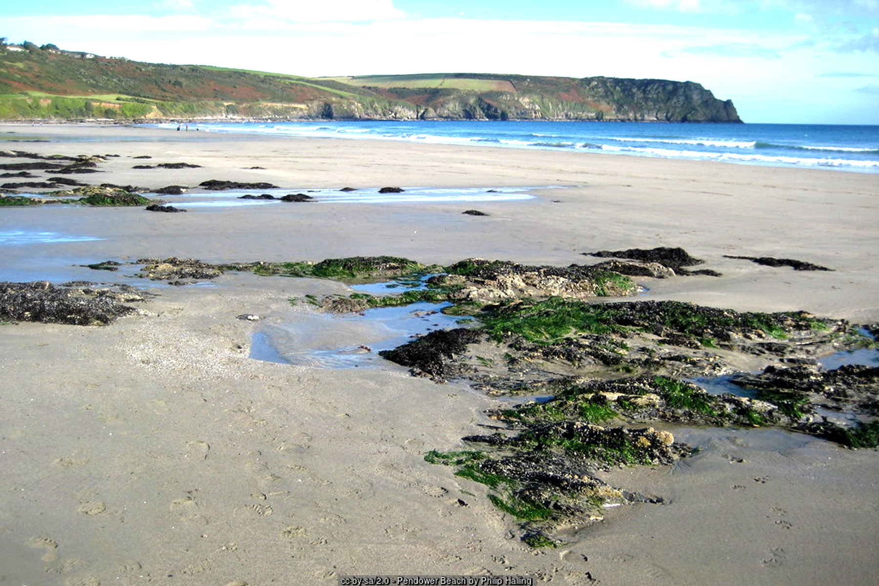
The beach itself has a distinct character from one end to the other. Towards its western end, where the sand gives way to rocky outcrops beneath the rising ground towards Nare Head, low tide reveals a good scatter of rock pools worth exploring, with the usual show of anemones, small crabs and blennies typical of this sheltered stretch of coast. The eastern section, closer to the join with Carne, is wide, flat and consistently sandy, and is generally the easier and more family-friendly part of the beach for young children, sandcastle-building and a straightforward paddle. A small stream crosses the beach on its way down to the sea, a reminder of the shallow valley that drains down to Pendower from the farmland and lanes behind - worth a note for anyone bringing very young children, since it can mean an extra channel of water to negotiate depending on where you choose to set up for the day.
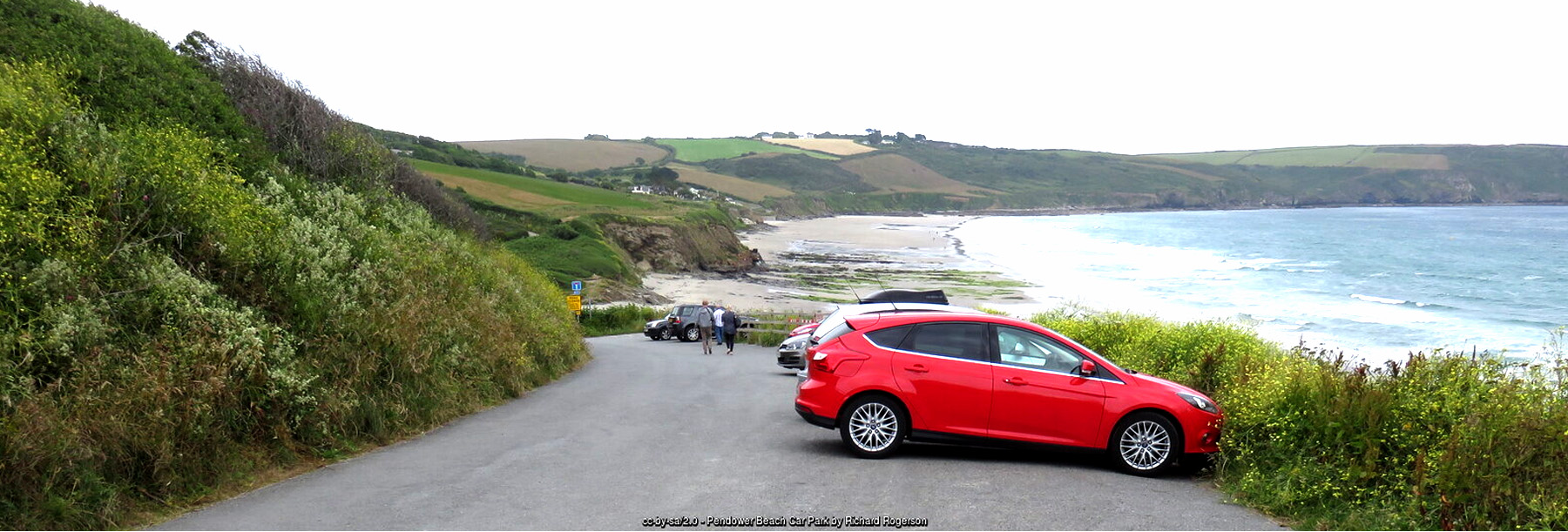
Pendower forms part of the National Trust's "Carne and Pendower" property, a holding that covers both beaches together with the dunes, cliffland and farmland behind them. The Trust's stewardship here has kept this stretch of Gerrans Bay free of the caravan parks and holiday development found on parts of Cornwall's more built-up coast, so the dunes behind the beach remain a genuinely undeveloped, semi-natural landscape of marram grass and coastal scrub rather than a managed amenity space. That conservation approach also explains the shape of the car park itself: rather than sitting directly on the beach, it is set back around 100 metres behind the dune line, a short and easy walk from the tarmac to the sand that keeps vehicles off the fragile dune system while still giving most visitors, including wheelchair and pushchair users, a straightforward, largely level route down to the beach.
The Roseland Peninsula, of which Pendower forms part of the southern shore, takes its name not from roses but from the Cornish word "ros," meaning heath or a spur of high, moor-like ground - the same root that gives the parish of St Just-in-Roseland its name at the peninsula's northern tip. It is a quieter, more agricultural landscape than much of the rest of coastal Cornwall, laced with deep tidal creeks off the Fal estuary to the north and, along its southern edge here at Gerrans Bay, a run of open sandy beaches and low cliffs quite different in character from the peninsula's inland lanes and wooded creek-sides. The whole coastline sits within the Cornwall National Landscape (the area of outstanding natural beauty designation, recently rebranded from AONB), and Gerrans Bay's south-facing, gently curving shape gives it noticeably more shelter from the prevailing south-westerly winds than the more exposed beaches on Cornwall's north coast.
On the high ground between Pendower and Carne stands Carne Beacon, a large Bronze Age round barrow and one of the biggest surviving burial mounds in Cornwall, its size alone enough to mark it out on the skyline above the two beaches. Local legend links the barrow to Gerennius (Geraint), a semi-legendary early Cornish king said to have given his name to the nearby village of Gerrans, and the tale - repeated in guidebooks for generations rather than historically verified - holds that he was buried standing upright in a golden boat with silver oars beneath the mound. Whatever the truth of the legend, the barrow itself is a genuine and substantial piece of prehistoric Cornwall, and its position directly above the join between Pendower and Carne means it is visible from much of both beaches, a quietly ancient backdrop to a very modern day at the seaside.
Pendower lies on both the Cornish Way Cycle Route, the long-distance cycling route that threads down through Cornwall to Land's End, and the South West Coast Path, which runs along the cliffs above the beach in both directions. Heading east from Pendower, the coast path climbs towards Nare Head, a National Trust headland rising above the far end of Gerrans Bay with some of the best coastal views on the Roseland, taking in the sweep of the bay behind and, on a clear day, the coastline running on towards Dodman Point. Just offshore from the headland sits Gull Rock, a small rocky islet that hosts a seasonal colony of nesting seabirds, regularly visible from the coast path above. It is an easy, rewarding stretch of walking either as an extension to a beach day or as a route in its own right, and the flat, direct line of the Cornish Way makes Pendower a natural stopping point for cyclists working their way down the peninsula too.
Inland and along the coast, Pendower sits within easy reach of the Roseland's principal villages. Portscatho, a small working fishing village a couple of miles to the north, is the nearest hub for shops, cafes and everyday services, while Gerrans itself, the larger parish that gives its name to the bay, lies just behind the beach on the lane down from the main Roseland road. Veryan, a little further inland, is well known for its distinctive round, thatched cottages, unusual survivors of an early-19th-century building fashion said locally to have been built without corners so the devil would have nowhere to hide - one of several small pieces of Roseland folklore that visitors exploring beyond the beach itself tend to come across.
Geologically, this stretch of the Roseland's south coast is built on the Devonian slates typical of much of south Cornwall, weathered here into the low cliffs and rocky western foreshore that frame Pendower's dunes and sand. The dune system itself, though modest by the standards of Cornwall's larger north-coast dune complexes, supports its own community of coastal plants and insects, and the sheltered, south-facing aspect of the whole bay creates a noticeably milder microclimate than beaches further round the coast - one reason the beach and its car park stay busy with dog walkers well outside the main summer season.
Pendower's own name is thought to derive from the Cornish "pen dowr", roughly "head of the water" or "end of the stream" - a fitting description given the small stream that crosses the sand on its way to the sea, and a naming pattern echoed at coves and beaches all around Cornwall wherever fresh water reaches the coast. Like the rest of Gerrans Bay, the beach sits on a foundation of Devonian slate, weathered over millions of years into the low, rocky ledges at its western end and the gentler, sand-covered ground towards Carne; choughs and other coastal birds are occasionally seen working the cliffs towards Nare Head, and grey seals are sometimes spotted off this stretch of coast, hauled out on rocks or fishing the margins of the bay. Anyone lucky enough to see one should keep a respectful distance and let the animal be, as with any wild seal encountered on the Cornish coast.
Walking options from Pendower run in both directions. Heading west along the coast path leads towards Porthcurnick and on to Portscatho, taking in some of the quieter stretches of cliff on this side of the bay; heading east across the sand towards Carne, and on past Nare Head, opens up the more remote coves of Paradoe and Kiberick and, further still, the strikingly unspoilt harbour village of Portloe - a full day's coastal walking is easily built around Pendower as a starting point, whether the plan is a short there-and-back stroll or a longer route linking several of the Roseland's beaches in one outing.
Practically, Pendower is one of the more straightforward Roseland beaches to visit. The large National Trust car park has good capacity even by the standards of Cornwall's busier beaches, the walk down to the sand is short and largely level, and with dogs welcome all year round there is rarely a reason not to visit outside peak summer weeks. There is no RNLI lifeguard cover here, as at most of the smaller beaches along this coast, so swimmers should keep a sensible eye on conditions, particularly around the mouth of the stream and on the falling tide when the sandbar out towards Carne begins to reveal itself. For anyone planning to make the most of that low-tide connection, checking the tide times before setting out is well worth the few minutes it takes, since the same falling water that opens up over a mile of continuous sand will, a few hours later, close the gap again.
Visitor Information
Parking
A large National Trust car park sits behind the dunes, around 100 metres from the beach - a short, easy walk down to the sand. Pendower also lies directly on the Cornish Way Cycle Route.
Facilities
Pendower is an undeveloped National Trust beach with no shop, cafe or lifeguard cover on the beach itself. The nearest everyday facilities are in Portscatho, a couple of miles along the coast.
Disabled Access
The route from the car park to the beach is short and largely level, giving Pendower easy disabled access by the standards of a dune-backed Cornish beach. No dedicated Blue Badge bays are confirmed at the car park - check current signage on arrival.
Things to Do Nearby
- Porthcurnick Beach, another Roseland beach a short drive or coast path walk to the north
- Carne Beach, joined to Pendower at low tide by over a mile of continuous sand
- Nare Head, a National Trust headland to the east with fine coastal views and seabirds on Gull Rock, reached along the South West Coast Path
Places to Stay
Pendower has no accommodation hub of its own; the nearest genuine base is Portscatho, the small fishing village a couple of miles along the coast:
Frequently Asked Questions
Page last updated: 17 September 2026