Porthkidney Sands
St Ives Bay's Wild Estuary-Mouth Beach and the Dunes of Lelant Towans
Porthkidney Sands (Lelant Towans), near Lelant, St Ives, Cornwall, TR26 3DU
Porthkidney Sands, also known locally as Lelant Towans after the dune system it backs onto, is one of the largest and least crowded stretches of sand anywhere in St Ives Bay. It lies at the mouth of the Hayle Estuary, immediately below the village of Lelant and only a couple of miles short of St Ives itself, and at low tide it opens out into a vast, gently sloping expanse of pale golden sand that can feel almost deserted even at the height of summer - a striking contrast to the packed town beaches a short walk or train ride away. Behind the beach, a broad belt of dunes rolls back towards the fairways of the West Cornwall Golf Club and the houses of Lelant, while ahead the sand runs on for the best part of a mile towards Carbis Bay, its character shifting gradually from soft, dune-backed estuary shore to firmer sand and, eventually, low cliffs as St Ives Bay curves round towards Hawk's Point.
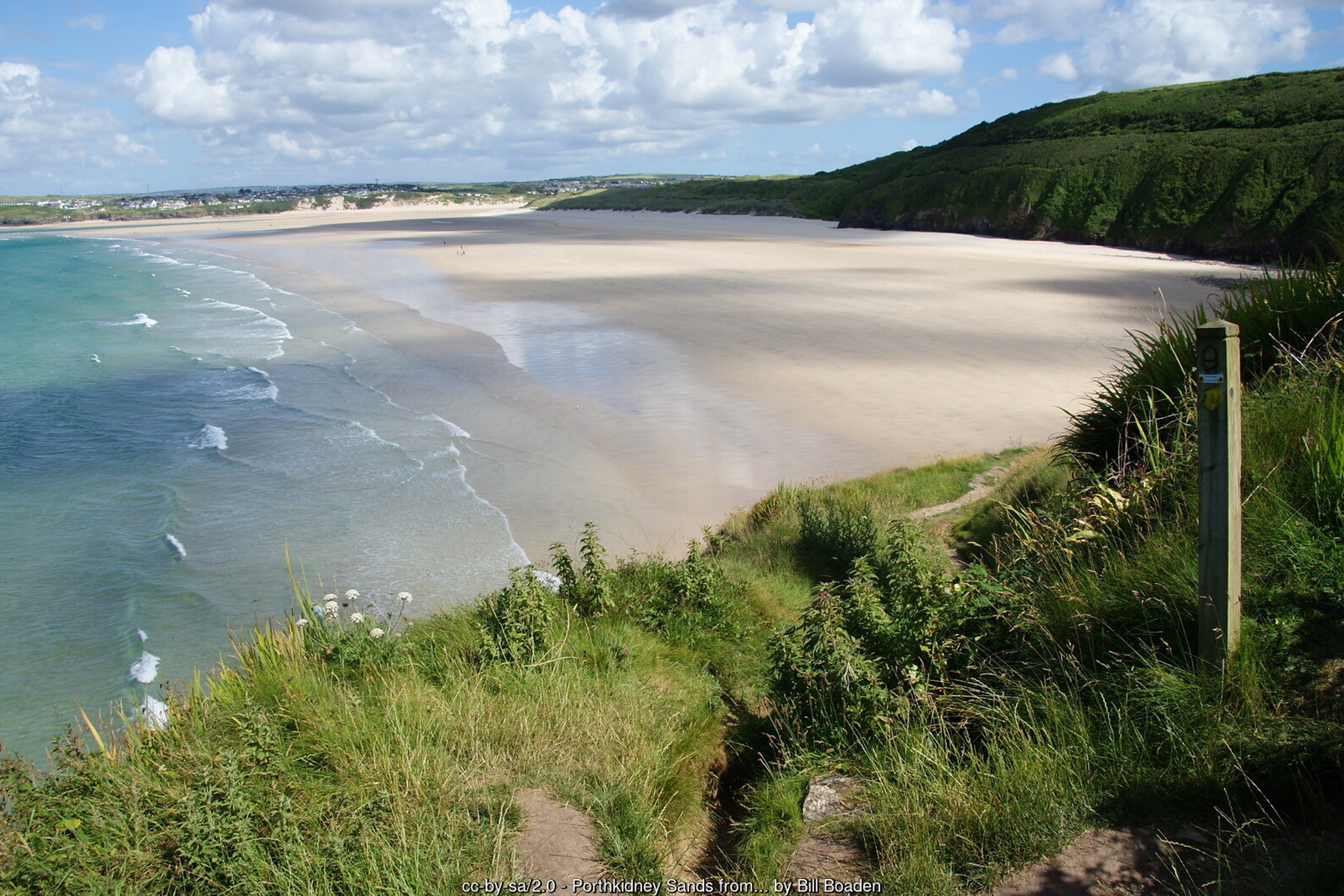
What keeps Porthkidney this quiet is largely a matter of infrastructure - or the lack of it. There are no facilities on the beach at all: no toilets, no café, no lifeguard cover, and only very limited road parking at the end of the lane down from Lelant, which fills within minutes on a sunny day. Most visitors instead reach it on foot, either along the South West Coast Path from Lelant, Carbis Bay or St Ives, or via the Lelant and Lelant Saltings railway halts a short walk from the sand. That absence of a proper car park is precisely why Porthkidney has kept its wild, undeveloped feel while beaches with easier access nearby have grown busier - anyone prepared to walk in is rewarded with a huge beach they may well have largely to themselves.
One of Porthkidney's most distinctive features isn't on the beach at all, but running along the top of it: the St Ives Bay branch railway line, one of the most scenic short train journeys in Britain, threading its single track along the dune tops between Lelant Saltings and Carbis Bay before climbing on towards St Ives. The line opened in June 1877 as the last new broad-gauge passenger railway built anywhere in Britain, was converted to standard gauge in 1892, and survived the Beeching cuts of the 1960s thanks to a reprieve from the then Transport Minister Barbara Castle - it has run as a designated community railway since 2005. Lelant Saltings, opened in 1978, was purpose-built as a park-and-ride station for St Ives; Lelant itself is a request stop served by only around half the line's daily trains. Whichever service you catch, the short stretch above Porthkidney is the highlight of the whole run: the line sits high on the dunes, giving passengers close-up, elevated views straight down onto the sand, the estuary and the bay beyond, and it is routinely rated among the most picturesque short railway journeys in the country.
The dunes themselves are shared with the West Cornwall Golf Club, whose links course occupies much of the high ground immediately behind the beach between Lelant and Carbis Bay. Founded in 1889, it is the oldest golf club still playing in Cornwall, laid out over genuine, naturally-draining links turf that plays well all year round. The club's honours board includes 'Long' Jim Barnes, a four-time major championship winner associated with the club in its early history, and it has produced two Walker Cup players in Philip Rowe (1999) and Harry Hall (2019) - Hall has gone on to a successful career on the US PGA Tour. The course and the railway line run almost side by side along this stretch of dunes, and walkers on the coast path get glimpses of both the fairways and the passing trains as they pick their way along the top of the beach.
Lelant itself, the village immediately above the beach, has a history considerably grander than its present quiet size suggests. In the medieval period it was an important seaport, with its own market and customs facilities, trading from quays on the Hayle Estuary before the channel gradually silted up and trade shifted downstream to Hayle and St Ives. Sand has shaped the village's history as directly as water: a parish record from 1727 describes around 50 acres of land and the vicarage as having been "overwhelmed by sand," and when the railway was built through the dunes in 1875, navvies uncovered several human skeletons, graves and the remains of a building, thought to be the site of a pre-Norman church buried by exactly that kind of sand encroachment centuries earlier. The present St Uny's Church stands at the eastern edge of the village on the fringe of the towans, overlooking the golf course, and is also the traditional starting point of St Michael's Way, a 12.5-mile pilgrim route established in 1994 that runs across the Penwith peninsula to St Michael's Mount - itself an ancient link between the north and south Cornish coasts, since it let pilgrims and traders avoid the long and often dangerous sea passage around Land's End.
Geographically, Porthkidney is defined by the estuary at one end and the open bay at the other. At its widest, low-tide extent the beach runs for close to a mile, from the Hayle Estuary mouth in the south-west round to the base of the cliffs near Carbis Bay in the north-east, and the sand is deceptively large - what looks from the coast path like a modest cove opens out, once you're down on it, into one of the biggest continuous stretches of sand anywhere in St Ives Bay. The Lelant end is soft and dune-backed, with easy if occasionally steep sandy access from the towans; the Carbis Bay end is rockier, with low cliffs, a scattering of sea caves cut into the soft slate, and a noticeably more dramatic, enclosed feel than the open dune country further along.
That same geography brings real hazards, and Porthkidney should be treated with more caution than a typical family beach. Currents around the Hayle Estuary mouth can run strongly, particularly on a dropping tide, and swimming anywhere near the river channel itself is not advised - the combination of river flow and tidal exchange can create currents that are hard to judge from the shore. With no lifeguard cover at any time of year, anyone swimming here is doing so entirely at their own risk, and checking tide times and local conditions before going in is essential rather than optional. Towards the St Ives end, the low cliffs backing the beach carry a minor but real risk of falling rock or debris, so it's sensible not to linger directly beneath them, especially after wet weather.
The estuary at Porthkidney's southern end is part of the wider Hayle Estuary, one of the most important sites in Cornwall for wading birds and wildfowl, and birdwatchers regularly scan the mudflats and channel from the Lelant shore for redshank, curlew, oystercatcher and the occasional rarer migrant, particularly outside the summer season. The dunes behind the beach, part of the same Towans dune system that continues round the bay through Hayle, Upton and Gwithian, support the usual mix of marram grass, sea holly and other sand-binding plants, along with skylarks and other ground-nesting birds in the quieter stretches away from the golf course and the railway - a reminder that this beach sits within a genuinely large and largely intact dune landscape, not an isolated pocket of sand.
Porthkidney rewards walkers as much as sunbathers. The South West Coast Path runs the full length of the beach, high on the dunes for most of the Lelant stretch before dropping closer to the shore towards Carbis Bay, and it's easy to combine a visit here with a longer walk in either direction - south towards Lelant village, St Uny's Church and the estuary shore path towards Hayle, or north-east over the low cliffs into Carbis Bay and on to Porthminster and St Ives itself, a walk that takes in some of the best coastal views anywhere in the bay, including distant sightlines to Godrevy Lighthouse across the water. Because so much of the beach is only really reached on foot, a visit here tends to be a deliberate, unhurried outing rather than a quick stop, which suits the beach's genuinely wild, uncommercialised character.
Dogs are welcome at Porthkidney Sands all year round, with no seasonal restriction - a notably more relaxed policy than the town beaches closer to St Ives, several of which apply a summer ban. Combined with the size of the sand at low tide and the relative lack of crowds, that makes Porthkidney a popular choice with dog walkers from across the bay, particularly out of season when the whole beach can feel almost private. The best time to visit is generally a couple of hours either side of low water, when the full extent of the sand is exposed and the walk between Lelant and Carbis Bay along the shore becomes possible; check a tide table before setting out, since the return route can be cut off as the tide rises.
Visitor Information
Parking
Only very limited road parking at the end of the lane down from Lelant, filling quickly in fine weather. There is no dedicated beach car park - most visitors arrive on foot via the coast path or Lelant / Lelant Saltings railway halt.
Facilities
None on the beach itself - no toilets, no café and no lifeguard cover at any time of year. The nearest facilities are back in Lelant village or across the estuary in Hayle.
Disabled Access
Access is on foot only, over soft dune paths or the coast path, with no level route from a car park onto the sand - this makes Porthkidney one of the more difficult beaches in the area for wheelchair or pushchair users. No Blue Badge parking is available at the beach itself.
Things to Do Nearby
- Carbis Bay, the next beach heading north-east towards St Ives, reached along the coast path or by train
- Hayle Towans, the beach on the far side of the Hayle Estuary mouth
- West Cornwall Golf Club, Cornwall's oldest golf club, its links course laid out over the dunes immediately behind the beach
- Lelant village and St Uny's Church, the traditional starting point of the St Michael's Way pilgrim route
- South West Coast Path, Lelant to Carbis Bay - a scenic walking route running the full length of the beach
Places to Stay
Frequently Asked Questions
Page last updated: 9 September 2026.