Discover a coastline where ancient Carboniferous sandstones
and shales have been compressed into spectacular folds,
creating some of the most striking geological exposures in
south-west England.
From the cliffs around Bude to the dramatic chevron folds of
Millook Haven and Crackington Haven, the Culm Coast reveals
a remarkable story of deep-water sedimentation, mountain-building
and millions of years of erosion.
The coastline around Bude, Millook Haven and Crackington Haven
provides an exceptional opportunity to examine the structure
of the rocks beneath north Cornwall. Layers of sandstone,
mudstone and shale were deposited during the Carboniferous
Period, roughly 359 to 299 million years ago – the rocks
at Bude itself are around 315 million years old. Geologists have
long called these rocks the Culm, after the thin seams of
soft, sooty coal found in them, and the stretch of coast from
Bude north towards Hartland is known as the Culm Coast.
These sediments accumulated in ancient basins under changing
marine and delta-influenced conditions. Some layers were laid
down by sediment-laden underwater currents, while other parts
of the succession record shallower-water, deltaic and lake
environments. The precise environment varies between formations
and through the sequence.
Later, powerful tectonic forces compressed the rocks during
the Variscan mountain-building episode. Instead of remaining
flat, the original sedimentary layers were bent, folded,
fractured and, in places, overturned. Subsequent erosion by
the sea has exposed these structures in the cliffs and
foreshore, allowing visitors to see the results at close range.
The area is especially important for understanding how
sedimentary rocks behave when subjected to intense compression.
The sharply angular folds at Millook Haven are a particularly
memorable example.
Geological Highlights
Carboniferous sandstones and shales
The Culm Basin and its sedimentary history
Chevron and recumbent folds
The Variscan mountain-building episode
Folded strata at Millook Haven
Coastal exposures around Bude and Crackington Haven
Weathering and erosion along the north Cornwall coast
The Culm Coast in Pictures
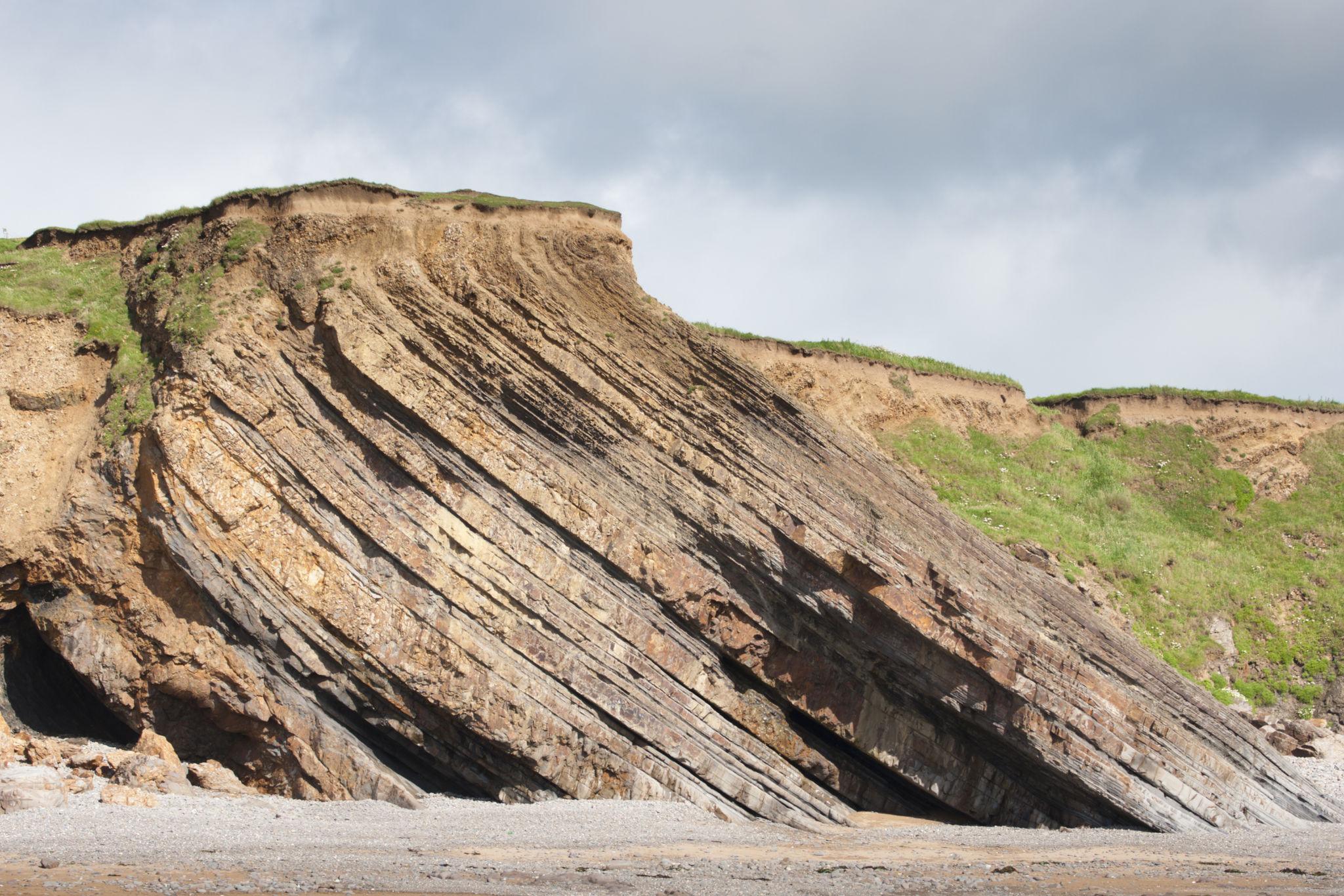
The coastline provides a natural cross-section through
folded Carboniferous rocks, from the sandstone cliffs of
Bude to the zig-zag folds of Millook Haven.
The Bude Coast
Coastal exposures reveal the alternating sandstones
and mudstones of the Carboniferous succession.
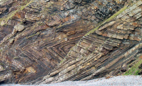
Millook Haven
Tight, angular folds make Millook Haven one of
Cornwall's best-known examples of folded strata.
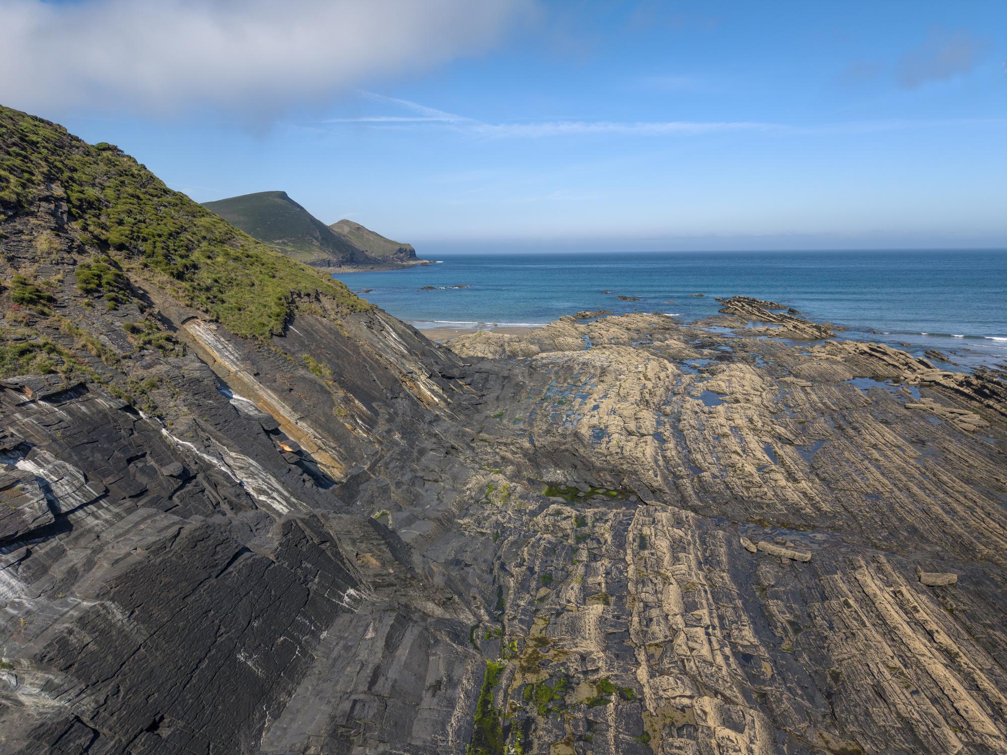
Crackington Haven
Sandstone and shale layers provide further evidence
of the region's complex sedimentary and structural history.
The Geological History of the Culm Coast
The rocks along this coast record several stages in the development
of an ancient sedimentary basin and its later deformation.
1. Carboniferous Sedimentation
During the Carboniferous, the region formed part of a
sedimentary basin in which mud, silt and sand accumulated.
The deposits became layers of mudstone, shale, siltstone
and sandstone as they were buried and compacted.
Some sandstone beds record sediment transported by
underwater density currents. Other beds and formations
record changing water depths and deltaic or lake-related
conditions. These changes are preserved in the rock sequence.
2. Burial and Lithification
As additional sediment accumulated, the lower layers were
buried beneath increasing thicknesses of material. Compaction
squeezed water from the sediment, while minerals helped bind
grains together to form sedimentary rock.
The resulting alternation of relatively resistant sandstone
and generally finer-grained mudstone or shale created layered
rocks that would later respond differently to tectonic stress.
3. Variscan Compression
Later in the Carboniferous and into the Permian, continental
collision and associated tectonic movements compressed
rocks across south-west Britain. This mountain-building
episode is known as the Variscan Orogeny.
The Culm Basin succession was folded and faulted. The
orientation, tightness and shape of individual folds vary
across the region, reflecting the complexity of the
deformation.
4. Erosion and Exposure
Over millions of years, uplift, weathering and erosion
gradually exposed the folded rock succession. Along the
north Cornwall coast, waves and cliff erosion reveal
structures that would otherwise remain hidden underground.
The modern cliffs are therefore a natural geological
record, although exposure changes over time and some
sections may be covered by beach material or fallen rock.
Sandstone, Shale and the Culm Succession
The term "Culm" is historically associated with the Carboniferous
rocks of Devon and north Cornwall. Modern geological mapping
distinguishes a number of named groups and formations within
this wider succession.
Crackington Formation
The older of the two local formations, the Crackington
Formation is made mainly of rhythmically bedded dark
mudstones with grey turbidite sandstones and siltstones.
Its partial type section is about 10 km of sea cliffs
between Rusey Cliff and Wanson Mouth, named after
Crackington Haven.
The formation is particularly relevant to the folded
Carboniferous rocks seen along sections of the north
Cornwall and north Devon coast.
Bude Formation
The Bude Formation is characterised by thick sandstone
beds alternating with mudstones and shale intervals.
Some beds are massive, while others preserve sedimentary
structures that help geologists interpret their origins.
The formation is named after Bude; its type section is
the coast north of the town between Duckpool and Gull
Rock, exposing about 1,290 m of strata. The British
Geological Survey describes it as laid down in a large
freshwater lake, with occasional marine incursions
recorded by black shale bands.
Bideford Formation
Across the border in north Devon, around Westward Ho!
and Bideford, the Bideford Formation sits between the
Crackington and Bude Formations. It includes mudstones,
siltstones and thick cross-bedded sandstones arranged
in coarsening-upward cycles.
It is not exposed on the Cornish coast, but helps explain
how the basin filled up between Crackington and Bude
times.
Formation boundaries and the rocks exposed at any particular
location should be checked against British Geological Survey
mapping. Similar-looking beds are not necessarily part of
the same formation.
The Famous Chevron Folds
One of the most remarkable features of the Culm Coast is the
sharp zigzag pattern formed by folded sedimentary layers.
These are known as chevron folds, named for
their angular, V-shaped or zigzag appearance.
Chevron folds commonly develop where alternating layers of
contrasting mechanical properties are compressed. Strongly
layered rocks can buckle into relatively straight limbs joined
by sharp hinges, producing a distinctive angular geometry.
The folds at Millook Haven are particularly striking and have
been highlighted by the Geological Society of London as a
major geological site.
How the Folds Formed
Sand and mud accumulated in an ancient basin and became
layers of sandstone and finer-grained sedimentary rock.
Burial and lithification turned the sediment into
solid rock.
Later tectonic compression shortened the rock succession
and caused the layers to buckle.
Continued deformation tightened the folds and, in some
places, rotated or overturned the rock layers.
Coastal erosion exposed the folded strata in the cliffs
and on the foreshore.
What to Look For
Fold limbs: the relatively straight
sections between the hinges.
Hinges: the sharper bends where the
direction of the beds changes.
Repeated layers: folded strata may
bring similar beds back into view more than once.
Contrasting rock types: sandstone and
mudstone layers can respond differently to compression
and weathering.
Structural orientation: bedding may
dip steeply and can be overturned in places.
Not every fold on the Culm Coast has the same shape. Some are
upright, while others are inclined, tight or recumbent. Their
geometry records the complex deformation of the Carboniferous
rocks and should be interpreted from the actual exposure rather
than from a single photograph.
Where to Explore the Geology
Several coastal locations around Bude provide opportunities
to observe sedimentary layers and deformation. Exposures vary
with tide, weather and beach conditions, so plan visits carefully.
Bude and Bude Haven
Bude gives its name to the Bude Formation, an important
part of the Upper Carboniferous succession of north
Cornwall and north Devon. Coastal exposures in the
wider Bude area reveal thick sandstone beds, mudstone
intervals and folded strata.
Look for: changes in bed thickness,
sandstone and mudstone alternations, sedimentary
structures and folded rock layers.
Millook Haven is famous for its tightly folded
sedimentary rocks and dramatic chevron patterns.
The cliff section provides an exceptional illustration
of how layered rocks can buckle under compression.
Look for: angular fold hinges,
straight fold limbs and repeated bands of sandstone
and finer-grained rock.
Crackington Haven and the surrounding coastline provide
further exposures of the Carboniferous succession.
The rocks illustrate the relationships between
sedimentary layering and later deformation.
Look for: sandstone beds, finer-grained
intervals, dipping strata and evidence of folding.
Check local geological mapping for the formation at
a specific exposure.
The wider coastline around Bude includes further
sedimentary exposures. The appearance of the rock
platform and cliffs changes with tides, weathering
and the movement of beach material.
Look for: bedding, joints, changes
in rock type and the contrast between more resistant
sandstone and finer-grained beds.
The north Cornwall coast is exposed to Atlantic weather and
powerful waves. Geological observation is best undertaken
from safe public viewpoints and established paths, with care
around cliff edges and the foreshore.
Check the Tides
Some rock exposures are easier to see at lower water.
Check local tide times and allow plenty of time to return.
Never enter a cove or foreshore route if the tide could
cut off your exit.
Cliff Safety
Keep away from cliff edges and the base of unstable
cliffs. Rockfalls can occur without warning, and wet
rock platforms may be slippery. Follow local signs
and coast path guidance.
Observe Without Damage
Use photographs and field notes to record folds and
bedding. Avoid hammering, breaking or removing rock
samples where this is prohibited or could damage
important geological exposures.
Use Geological Maps
Consult the British Geological Survey's mapping before
assigning a formation name to a particular outcrop.
Geological boundaries may be complicated by folding
and faulting.
Explore More of Cornwall's Geology
The Culm Coast is one part of Cornwall's geological story.
Compare its strongly folded Carboniferous rocks with the
Devonian sedimentary formations and granite landscapes
found elsewhere in the county.
The cliffs north and south of Bude are made of the Bude Formation – thick beds of grey sandstone with mudstones and a few distinctive black shale bands. They are Upper Carboniferous in age, roughly 315 million years old. The type section of the formation is the coast north of Bude, between Duckpool and Gull Rock.
‘Culm’ is an old name for the soft, sooty coal found as thin seams in the Carboniferous rocks of Devon and north Cornwall. Geologists borrowed it for the whole succession, which is now formally called the Culm Supergroup. The stretch of coast between Bude and Hartland is often called the Culm Coast.
The best-known folds are at Millook Haven, south of Widemouth Bay, where the cliff face shows a stack of sharp zig-zag folds. Crackington Haven and the cliffs north of Bude, around Northcott Mouth and Sandymouth, also show folded beds. The folds are best seen from the beach at low tide.
The sandstones and mudstones were laid down as flat layers. Towards the end of the Carboniferous, the Variscan mountain-building episode squeezed the region from the south. Because the rocks were made of alternating strong sandstone and weaker mudstone layers, they buckled into folds with straight limbs and sharp hinges – the classic chevron shape.
Not entirely. The British Geological Survey describes the Bude Formation as deposited in a large freshwater lake on a broad shelf, with sand carried in by river-fed underwater currents. Thin black shale bands with marine fossils record times when the sea flooded in. The older Crackington Formation, seen at Crackington Haven, is made of deeper-water turbidite sandstones and mudstones.
Fossils are not common, but some black shale bands contain nodules with goniatites (coiled shelled animals related to squid) and fish remains, and trace fossils can be found on bedding surfaces. Please photograph rather than hammer the cliffs.
Millook Haven is one of the Geological Society of London’s 100 Great Geosites in the UK and Ireland, chosen for its spectacular folds. Treat it, and the rest of the coast, as an outdoor museum: look, photograph and leave the rocks in place.
The north Cornwall coast faces the Atlantic and the cliffs are unstable. Check tide times before you go, keep away from the base of the cliffs, take care on slippery rock platforms, and make sure the incoming tide cannot cut off your way back.
The following sources provide additional information about
the folded Carboniferous rocks, geological formations and
regional history of the Culm Coast.
Geological terminology and formation boundaries follow published
geological sources. Individual exposures should be checked
against current geological mapping, especially where strata
are tightly folded or faulted.