Cornwall's geological heritage

The Meadfoot Beds and the Geology of South-East Cornwall

Discover the ancient sedimentary rocks, buried basins, folded strata and major faults that shaped the landscape between Looe, Polperro, Whitsand Bay and the Rame Peninsula.

Early Devonian rocks Structural geology British Geological Survey

Explore the geology
Back to Geology of Cornwall

An ancient geological landscape


The Meadfoot Beds are an important part of the geological history of south-west England. The name originated from exposures at Meadfoot Beach in Torquay and was historically used for Early Devonian sedimentary rocks across parts of Devon and Cornwall.

Modern geological mapping generally uses the name Meadfoot Group. In the Plymouth and south-east Cornwall district, it includes the Bovisand Formation and the Staddon Formation.

These rocks were deposited approximately 400 million years ago, when sediments accumulated in a changing landscape of rivers, deltas and marine basins. Much later, powerful tectonic forces compressed the region, folding the rocks and pushing enormous packages of strata over one another.

The resulting geology is complex. A cliff that appears to show a simple sequence of layers may actually contain overturned strata, repeated beds or rocks brought together by a major thrust fault.

The key geological story

The Meadfoot Group records the original sedimentary history of the region, while its folds, cleavage and fault relationships reveal the much later deformation that transformed south-east Cornwall during the Variscan Orogeny.

Geology at a glance

Age

Early Devonian, broadly around 400 million years ago.


Main rock types

Mudstone, slate, siltstone, sandstone and local limestone beds.


Original environment

Marine sedimentary basins, within a region that experienced changing continental and marine conditions.


Later deformation

Folding, thrusting, strike-slip faulting and later extensional reactivation.

How the geology developed


The rocks preserve evidence of several major geological events, from Devonian sedimentation to later mountain building and renewed fault movement.

Early Devonian

1. Sediments accumulated

Rivers, deltas and marine processes transported mud, silt and sand into subsiding basins. The sediments were buried and consolidated into the rocks now exposed across the region.

Devonian

2. Fault-bounded basins developed

Extensional faulting created space for thick sedimentary successions. Differences in subsidence and sediment supply produced variations between individual basins and formations.

Carboniferous

3. Compression folded the rocks

During the Variscan Orogeny, compression produced folds, cleavage and major thrusts. Earlier basin structures were inverted and sedimentary packages were displaced and stacked.

Late Carboniferous onwards

4. Faults were reactivated

Later extension and renewed movement modified some earlier thrusts and faults. Subsequent erosion exposed the geological structures visible today.

What is the Variscan Orogeny?

The Variscan Orogeny was a prolonged period of continental convergence and mountain building that affected much of south-western Europe during the Devonian and Carboniferous.

In south-east Cornwall, compression transformed sedimentary basins into a complex arrangement of folds, thrust sheets and strike-slip faults.

Some faults originated during the earlier extensional phase. Later compression reused these weaknesses, sometimes reversing their original movement.

Read the BGS regional geological memoir

The Meadfoot Group rock formations


The modern classification distinguishes formations with different rock types and sedimentary characteristics.

Early Devonian

Bovisand Formation

The Bovisand Formation consists principally of grey slaty mudstone, siltstone and sandstone, with local limestone beds.

The BGS describes a succession at least 1,300 metres thick in the regional stratigraphical framework. It includes the Lower and Upper Long Sands Sandstone members.

Its fine-grained rocks are particularly useful for examining cleavage, folding and the effects of tectonic compression.


BGS Bovisand Formation entry
Early Devonian

Staddon Formation

The Staddon Formation consists mainly of sandstone with interbedded mudstone and siltstone.

The BGS gives a regional thickness of approximately 500 metres.

The contrasts between sandstone and finer-grained layers help reveal changes in sedimentation and the way individual beds respond to folding and faulting.


BGS Staddon Formation entry
Geological terminology: Older maps and publications may use the historical term “Meadfoot Beds” more broadly. The precise formation exposed at any location should be checked against the relevant BGS geological map.

The Looe Basin and its structure


The Looe Basin is central to understanding the geology of south-east Cornwall. The BGS interprets it as a fault-bounded sedimentary basin that developed through episodes of subsidence during the Devonian.

The basin contains three major structural subdivisions associated with the Freathy, Long Sands and Duloe sub-basins. During later compression, these became incorporated into a system of major thrust sheets.

These thrusts transported rock packages over neighbouring units and produced large folds near their fronts. Consequently, the present arrangement of formations does not always reflect their original depositional order.

The wider Plymouth district also includes the South Devon, Tavy and Culm basins. Their different ages and structural histories help explain the complexity of the regional geology.

What is a half-graben?

Schematic half-graben Layered sedimentary rocks tilted beside a major normal fault, creating a basin that subsides asymmetrically. Higher block Subsiding basin Sedimentary layers

Simplified illustration of asymmetric basin subsidence. It is a conceptual diagram, not a measured cross-section of the Looe Basin.

Folding: when the rocks buckle


Compression bent the sedimentary layers into folds ranging from small structures in individual beds to major folds extending across the region.

Upright geological fold Several sedimentary layers curve upwards into an arch and downwards into a trough. Folded sedimentary layers

Upright folds

In an upright fold, the axial plane is broadly vertical. Arches are described as antiforms and troughs as synforms; the terms anticline and syncline are used when the age order of the layers is established.

Overturned geological fold Curved geological layers with a strongly inclined axial plane and one limb rotated beyond vertical. Rotated rock layers

Overturned folds

Continued deformation can rotate one limb beyond vertical. Beds may then dip in the same general direction on both limbs, and the original order of strata may be inverted on one side.

D1: the first major deformation

The BGS describes widespread D1 folding, cleavage development, thrusting and strike-slip faulting. Fold trends are generally east-west to east-north-east–west-south-west, although local directions vary.

Many folds are tight or close, with some overturned. Antiforms commonly developed in the hanging walls of major thrusts.

D2 and D3: later modification

D2 produced further folding, crenulation cleavage and out-of-sequence thrusting. This means that some younger thrusts cut or modify older structures rather than forming only at the front of the thrust system.

D3 structures and subsequent fault movement added further complexity. Not every locality preserves every deformation phase equally clearly.

A note on geological interpretation

An arch-shaped fold is not automatically an anticline, and a faulted contact is not necessarily an original depositional boundary. Bedding, cleavage, facing direction and mapped fault relationships must be considered together.

The major faults of south-east Cornwall


Several large fault systems cut the region. Their movements occurred over different geological periods and included both horizontal and vertical displacement.

Cawsand Fault

A major north-west-trending structural boundary associated with changes in the orientation of bedding and cleavage. The BGS estimates a regional displacement of approximately 4 km.

Evidence near Kingsand indicates that the fault system experienced more than one movement phase.

Portwrinkle Fault

A major fault system with an estimated regional displacement of approximately 7.5 km. Its southern splay is known as the Rame Fault.

Fault breccia and intensely sheared rocks provide evidence of substantial movement and repeated reactivation.

Portnadler Fault

This fault offsets geological strike belts west of Looe. The BGS estimates a regional displacement of approximately 1.5 km.

Its relationship with neighbouring faults helps explain changes in bedding and cleavage orientation across the coastal district.

What is strike-slip movement?

A strike-slip fault allows blocks of rock to slide horizontally past one another. A dextral fault is right-lateral; a sinistral fault is left-lateral.

The principal faults in south-east Cornwall have predominantly dextral strike-slip displacement associated with their principal movement history, although vertical and later reverse-direction movements also occurred.

Fault displacement estimates represent cumulative geological offsets inferred from mapped relationships. They are not the width of the fault zone or the displacement of a single earthquake.

Schematic strike-slip fault Two blocks with matching rock layers are separated by a fault and have moved horizontally in opposite directions. Block A Block B

Conceptual diagram of horizontal fault displacement. Actual fault systems can also have vertical movement, rotation and multiple episodes of reactivation.

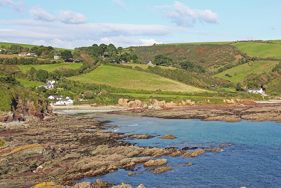
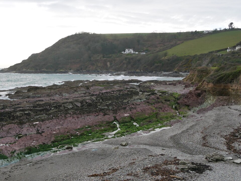
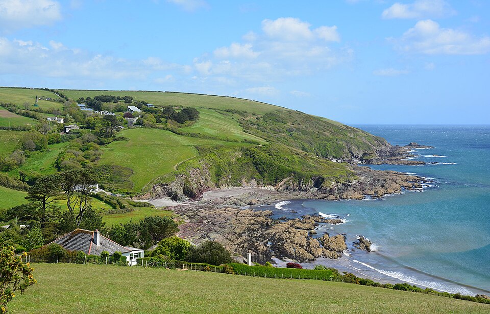
Talland Bay provides a useful coastal setting for exploring the geology of south-east Cornwall, with steeply tilted Meadfoot slates and sandstones exposed along the foreshore at low tide. These photographs show the bay and its surrounding coastline; consult the British Geological Survey mapping to identify the precise geological formations.

Coastal landscape at Talland Bay, Cornwall

Talland Bay

A view across the bay and its coastal landscape.

Photograph: Edmund Shaw, via Geograph. Licensed under CC BY-SA 2.0. Original source.

View of Talland Bay on the south-east Cornwall coast

The Coastal Setting

The shoreline and surrounding landscape of Talland Bay.

Photograph: Wayland Smith, via Geograph. Licensed under CC BY-SA 2.0. Original source.

Talland Bay and its surrounding headland in Cornwall

Bay and Headland

The headland and coastline around Talland Bay.

Photograph: Pete Cruse, via Geograph. Licensed under CC BY-SA 2.0. Original source.

Where to study the geology


The coast provides valuable exposures of sedimentary rocks, folds, thrusts and faults. The exact formation at each locality should be checked against BGS mapping.

1

Tregantle Cliff

An important coastal area for studying folded strata, small thrusts and relationships between the Whitsand Bay and Bovisand formations.

The BGS describes overturned folds and repeated sandstone beds in this coastal succession.

2

Black Ball Cliff

A notable locality for understanding the reversal of fault movement, where an earlier thrust was subsequently affected by extensional backslip.

Particularly useful for interpreting fault history rather than simply observing the present rock layers.

3

Freathy and Whitsand Bay

A valuable regional coastal section with major folds, variable fold-axis orientations and thrust-related structural relationships.

Suitable for examining the relationship between bedding, cleavage and folding.

4

Portwrinkle and Crafthole

An important area for studying the Portwrinkle Fault, the Rame Fault and the distribution of fault-bounded rock formations.

Useful for connecting coastal observations with regional structural mapping.

5

Polperro

The surrounding coastal district contains folded and locally overturned Devonian strata, alongside evidence of earlier growth faults.

A useful location for considering how sedimentation and later tectonic deformation interacted.

6

Looe and the inland valleys

The wider Looe area provides context for the Looe Basin, major antiformal folds and the influence of faults on the landscape.

The East Looe River valley north of Looe Mills follows a mapped north-south fault.

Before visiting a geological exposure

Check public access, tide times and coastal safety. Some rock platforms are accessible only at particular tidal states, and steep cliffs may be unstable. Do not enter restricted land or climb unsafe cliff faces.

How geology shaped the landscape


The hills, valleys and coastal cliffs of south-east Cornwall reflect the combined effects of rock type, geological structure and erosion.

Differential erosion

Resistant sandstone beds can form ribs and ridges, while softer mudstone and intensely fractured rock may erode more readily.

Fault-controlled valleys

Fault zones often contain fractured or crushed rock. Where erosion exploits these weaker zones, valleys may follow the direction of a fault for considerable distances.

Coastal erosion

The orientation of bedding, cleavage, joints and faults influences how rock blocks separate and how cliffs respond to wave attack and weathering.

Not every valley or coastal indentation is fault-controlled. Rock resistance, drainage, superficial deposits and changes in sea level also influence the modern landscape.

A landscape with a long history

The visible coastal scenery is the latest stage in a geological story that began with sediment accumulation in the Devonian.

The rocks were later folded, thrust and faulted, then exposed by uplift and erosion over millions of years.

Understanding this sequence helps explain why apparently neighbouring coastal exposures can contain rocks with very different structural histories.

Frequently asked questions


Meadfoot Beds is a historical term for Early Devonian sedimentary rocks now generally classified within the Meadfoot Group. In the Plymouth and south-east Cornwall district, the group includes the Bovisand and Staddon formations.

They are Early Devonian rocks, broadly around 400 million years old. Exact age assignments depend on the stratigraphical unit and the geological timescale used.

Later tectonic compression during the Variscan Orogeny folded and faulted the original sedimentary layers. Continued deformation rotated some limbs beyond vertical, producing overturned strata.

Major named structures include the Cawsand, Portwrinkle, Rame and Portnadler faults. Their histories include different combinations of horizontal displacement, vertical movement and later reactivation.

The British Geological Survey's GeoIndex Onshore provides access to geological mapping. Its regional memoir for Plymouth and south-east Cornwall provides detailed information about the formations, folds and faults. Open BGS GeoIndex Onshore .

Further reading and references


The following British Geological Survey resources provide the principal scientific references for the information on this page.

  1. Leveridge, B. E., Holder, M. T., Goode, A. J. J., Scrivener, R. C., Jones, N. S. and Merriman, R. J. (2002). Geology of the Plymouth and south-east Cornwall area. British Geological Survey, Sheet 348.
    Read the full geological memoir
  2. British Geological Survey. Meadfoot Group. Lexicon of Named Rock Units.
    View the Meadfoot Group definition
  3. British Geological Survey. Bovisand Formation. Lexicon of Named Rock Units.
    View the Bovisand Formation definition
  4. British Geological Survey. Staddon Formation. Lexicon of Named Rock Units.
    View the Staddon Formation definition
  5. British Geological Survey. GeoIndex Onshore.
    Explore geological mapping
  6. Seago, R. D. and Chapman, T. J. (1988). “The confrontation of structural styles and the evolution of a foreland basin in central south-west England.” Journal of the Geological Society, 145, 789–800.
    Geological Society publication archive

Geological interpretations and age assignments reflect the cited regional literature. The precise interpretation of individual structures may change as geological mapping and research develop.

Explore further

For detailed site-specific research, consult the BGS geological map alongside the regional memoir.

Compare mapped formation boundaries with the locations of folds, thrusts and strike-slip faults.

BGS GeoIndex BGS Geological Memoir

Geological information is provided for educational purposes. Consult the cited geological sources for detailed mapping and site-specific interpretation.

British Geological Survey · Back to top

Page views: 14 ·  2026 views: 14