Launceston In North Cornwalll - Holidays in Launceston Tourism Guide

Padstow | Wadebridge
| The Camel Estuary | Rock
| Polzeath | Port
Isaac | Trebarwith Strand
|Tintagel | Bossiney
Cove | Rocky Valley
| Boscastle | Crackington
Haven | Bude | Clovelly
| Launceston | Camelford
| Altarnum | Bodmin
 |
|
Where
to Stay in Launceston
Agricultural Contractor, Plant Hire, Groundworks and Excavation work based in East Cornwall.
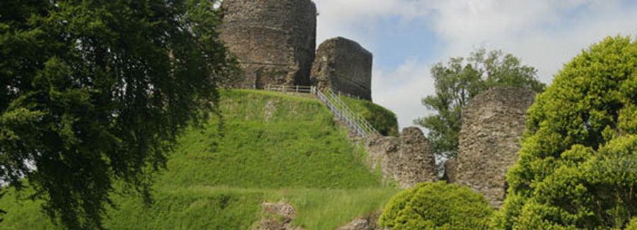
|
 |
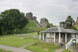 |
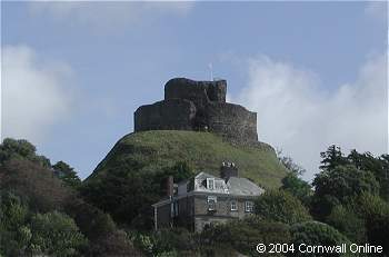
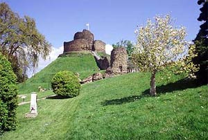
LAUNCESTON
Ancient capital of Cornwall
Launceston is the chief town of a wide area lying between Dartmoor and Bodmin Moor. In Saxon times it was the site of a Royal Mint. By the 12th century the town itself had become walled (the only walled town in Cornwall) and for centuries the Assizes were housed here, in the castle itself and Guildhalls in the town.
The Prince of Wales comes to Launceston once in his lifetime as Duke of Cornwall to receive the feudal dues which are his right within the Duchy.
Launceston has been and still is an important market centre; the rights to hold such markets were among the privileges granted by Royal Charter. These Charters and other historical papers are housed in the Archives of Launceston.
Other places of interest in Launceston, include Lawrence House which displays a variety of historical artefacts and is recognised as one of the finest museums in the South West..
The Northgate and Prison where the Quaker George Fox was imprisoned. The Southgate arch which incorporates an Art Gallery; and the Town Hall with its fine clock and quarterjacks to chime hours and quarters.
Launceston Priory was one of the wealthiest in Cornwall. After its consecration, the priory was dedicated to St. Stephen the Proto-Martyr. By the 14th Century Launceston Priory had become a large, stately monastic building. By the 16th Century, Launceston Priory was reaching its peak in both influence and wealth but following the dissolution of the Monasteries it was razed to the ground and never re-erected. The site was rediscovered in the late 19th Century during the construction of the railways and enough of the foundations were revealed to enable its size and layout of the building to be determined.
Launceston is now a busy Cornish Market Town with many
shops and businesses located in and around the Town Square.
LAUNCESTON TOWN TRAIL
The text below has been taken from a guide produced by Launceston Town Council and details a historical walk around the town. The information was originally intended to accompany you on your walk rather than be read over the Internet, but never the less provides a detailed account of what Launceston has to offer. You could say a Virtual Tour around the town.
 This
Trail covers much of that part of Launceston which was the core of the
Mediaeval town built within the Town Wall, now designated as a Conservation
Area of Outstanding Status. It contains examples of every significant
type of architecture since the Norman Conquest.
This
Trail covers much of that part of Launceston which was the core of the
Mediaeval town built within the Town Wall, now designated as a Conservation
Area of Outstanding Status. It contains examples of every significant
type of architecture since the Norman Conquest.
The starting point of the Trail is Walk House Car Park
in Tower Street.
1![]() Up the hill, past the Bell Inn - parts of which date back to the
17th century; note the arched granite doorway.
Up the hill, past the Bell Inn - parts of which date back to the
17th century; note the arched granite doorway.
2 - is the Church of St Mary Magdalene which was completed in 1542 and is built on the site of at least one earlier Church. It is unique in that its granite exterior is intricately carved on practically every stone. The fine tower was commissioned by the Black Prince in the 14th century. At the East end of the church is a recumbent statue of Mary Magdalene with her pot of precious ointment by her side. One of its many associated traditions says that if you can cast a pebble over your shoulder up onto her back and it stays there, then you will have a new suit of clothes. More detailed information about the building is available within the Church.
3 The Trail continues in an Easterly direction along Market Street. On the left is the Graveyard and on the right is the Church Stile, a fine Georgian House with plastered stucco finish. The proportions and design make it a perfect example of 18th century architectural style. Note the medallion eaves cornice and the stucco Grecian female faces formed on the window head keystones. The top storey was added about 1900 above the band stringing course.
Further along Market Street can be seen the fine old Market Building with its unusual curved roof slating. The principle light is obtained from clerestory windows high up in the roof and it has recently been converted into a splendid shopping arcade.
4 Bearing left of the market building one finds the Old Vicarage on the left hand side. The building is mainly 18th century and has a 17th century Tudor style arched gateway attached. Opposite this is to be found the present fish market which is on the lower ground level of the Market Building and has been so situated as long as can be remembered.
Turning right along the narrow lane beyond, known as Blind Hole, the row of buildings on the left have foundations superimposed upon the old Town Wall which is at least 400 years old.
5 At the top of Blind Hole on Southgate Street can be seen the only remaining gateway of the original three entrances to the old walled town. This is the Southgate Arch. The actual arch is Early English and the two rooms above were constructed in the time of Edward VI, son of Henry VIII, and further embellished with a battlement parapet in 1887 at the same time as the pedestrian arch on the right was given to the town (see plaque on wall). The blocks which bore the portcullis can be seen under the arch. On the town side of Southgate Arch note the granite site of one of the standpipes which were the towns first public water supply. The date there - 1825 - and the initials P.C.H. are those of the Mayor of the time, Parr Cunningham Hockin.
Race Hill, beyond Southgate Arch, leads to the Pannier Market (held Tuesdays and Saturdays) and large car parks.
6 The slate hung cottages and particularly the one leaning against the side of the Southgate Arch are very much as they were in the 18th century, and the very steep hill (Angel Hill) adjacent to the Arch was originally the main road into the town from England and leads to the 16th century Dockacre House.
In Southgate Street many of the buildings are of architectural merit, mostly 17th and 18th century, ranging from brick-faced No. 5 with its fine pediments, to the slate clad corner building on the left-hand side of the road. Philip Gidley-King, son of a Launceston draper, was born at No. 5 in 1758 and in 1800 he became the third Governor of New South Wales, Australia. It was in his honour that the daughter town of Launceston on the Tasmanian River Tamar was named. <
On the opposite side of the road is Ching's Alley which contains the old wine cellars with a vaulted brick ceiling, now part of an architecturally new commercial development.
8 Straight ahead in Church street the interesting buildings, restored in 1973, are No. 26 on the left, a 17th century town house and
9 No.20 with elliptical lights, slender twisted columns, Corinthian Pilasters and decorated frieze and cornice. (Site of an early Guildhall).
10 Turning left into High Street the buildings on the right back into Castle Dyke. No. 4 the Chemist's shop, which has recently been altered at ground level, is early 18th century with a plastered front and first floor overhang, having a painted gilded Phoenix (the sign of the Chemist) above the cornice in the centre of the frontage. The adjoining building is of exposed local stone with a fine pediment centre doorway and transom with a glazed oval panel.
11 At the top of High Street at the corner of the square, are Nos. 11 and 13, These buildings of 16th century origin were built for Thomas Hicks, Mayor of the town. Items of interest are the slate hangings, the panel studded house entrance door, the double hung sash windows with granite jambs and head which are believe to have been from the now ruinous St Thomas Priory. The devious route taken by the rain water downpipe is interesting. Through the window above the shop people could have witnessed scenes of the martyrdom of St Cuthbert Mayne in 1577 and later both Charles I and Cromwell could perhaps have been seen from there.
12 The centre of the Square is dominated by the War Memorial which was erected on the site of the old Town Butter Market. And it is little known that there is a large unused water reservoir beneath the Square (unfortunately not available for public viewing).
13 Proceed towards the White Hart Hotel which is another fine Georgian building with flat cambered arches over large double hung sash windows. It is said that the 12th century doorway was removed from St Thomas Priory. Alongside the White Hart are several other interesting frontages having richly carved medallion cornices and chamfered wooden corbels.
14 Over No. 5 Broad Street on the left can be seen a Golden Boot, an old sign of a Shopkeeper's craft.
15 Proceed through the Square, turning right to Western Road and you will find the Castle on the right and the Town's Guildhall with its intriguing clock on the left. Wait a minute or two and watch the quaterjacks strike a quarter-hour from their niche above the clock.
Behind the Town Hall can be seen the row of small cottages (c, early 18th century) at the top of Sheep Market Car Park.
16 Turn now into the Castle grounds through the imposing gateway in the Castle walls. Access to the Castle itself is obtained through the Keeper's Lodge where historical information is available. Recent summer excavations within the grounds can be seen where at least three levels of history have been unearthed. The lead pump dated 1739 is sited over the old Castle Keep Well.
Follow the path through the North-gate of the Castle, reading the plaques relative to the martyrdom of the Roman Catholic Saint, Cuthbert Mayne and telling how George Fox, the Quaker, was held in the tiny prison for many months.
Castle Street, where traces of the old cobble stones can be seen, is mainly Georgian architecture and has been greatly admired by John Betjeman, the late Poet Laureate. These buildings look very much as they must have done 250 years ago.
17 The Eagle House Hotel on the left, with Eagles on the gate posts, was originally a Town Hall built in the 18th century by the Constable of the Castle out of his winnings in a lottery.
18 No. 9 Lawrence House, is now owned by the National Trust and houses the local museum (well worth a visit) and the Mayor's Parlour. On the opposite side of the road is the handsome Queen Anne residence, Castle Hill House, soon to be restored.
Past the Museum on the right-hand side, adjacent to Castle Street Chapel, the Trail leads up to Northgate Street steps where can be found several delightful buildings which were typical of this street before redevelopment in the 1960's. At the top of the steps can be seen the Central Methodist Chapel built in 1870.
Before turning left into Tower Street, look back the way you have come. In the valley below is the River Kensey, St Thomas Church, the Priory Ruins and Prior's Bridge. Above, on the skyline, is the village of St Stephen's with its fine church standing out prominently. The village of St Stephens was originally a Celtic settlement and the site of the original Launceston and Royal Mint. All these historical treasures are soon to be the subject of an extension to this Trail.
Now turn left into our starting point, the Walk House Car Park and down the steps onto what is the top of the old town wall from which there are magnificent views of the Tamar Valley, Devon and Dartmoor.
Walking to your right and up the steps you will come
across a small terrace of 19th century houses. This is The Walk, a delightful
and quiet backwater of Launceston, with wonderful views of Devon.
It gets the name from the fact that the Townspeople's favourite (indeed,
almost there only) promenade was along the wide ramparts of the Town Walls
and, although they are now gone, The Walk retraces their path. From here
you will see why Launceston never had an Eastgate; there is virtually
a cliff to the valley below.
Proceed now up the final flight of steps which takes you to St Mary's Church, the recumbent Mary Magdalene, and the Town Centre. Notice the Preaching Cross amongst the gravestones opposite Mary Magdalene.
We hope that you have enjoyed your walk and that you will have time to visit some of the other places of interest in Launceston, i.e. the Steam Railway at Newport, Coronation Park and the Leisure Centre.
Please come again and explore our town for yourself. You will find many other things to gladden the eye and lift the spirit.

|
Where to Stay Locally |
|

 |
|
|
Late Vacancies & Special Offers |
 |
|
Promoting
your business on Cornwall Online |
|
Cornwall
Online is a trading name of Internet Trading Systems Ltd
Cornwall Online Website by Internet Trading Systems Ltd. Tel 01579 557343 Please ensure that you confirm all details with the Advertiser before Booking We recommend that you take out Holiday Insurance on ALL Bookings |