Tregantle Beach
Long Sands, a Mile of Beach Beneath a Victorian Fort at the Eastern End of Whitsand Bay
Tregantle, Torpoint, Cornwall, PL11 3AL
Tregantle Beach, known just as widely to locals as Long Sands, is the first of Whitsand Bay's great open stretches of sand reached travelling east from Portwrinkle, and in many ways it sets the tone for the whole four-mile bay: a huge, wild expanse of sand and shingle, reached only by a steep cliff path, and watched over the whole time by a looming Victorian fort. The beach takes its name from Tregantle Fort, one of a trio of Palmerston-era coastal defences built above Whitsand Bay in the 1860s, and the fort's continued use as an active Ministry of Defence training area and firing range remains the single most distinctive thing about a visit here - along with the scale of the sand itself, which at low tide runs on for the best part of a mile beneath the cliffs.
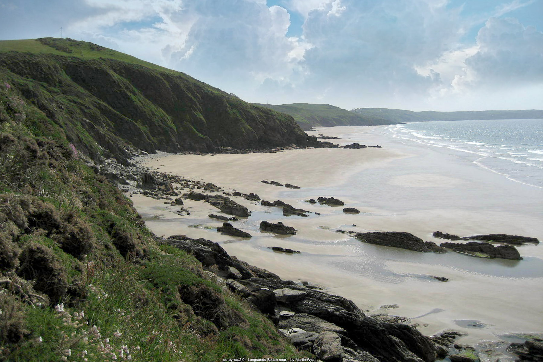
Geographically, Tregantle sits within the civil parish of Antony, on the Rame Peninsula in South East Cornwall, a few miles south of Torpoint and the Tamar crossings into Plymouth. The beach itself is a mixture of sand and shingle backed by high, unstable cliffs typical of this stretch of coast, with a scatter of rock at each end that holds pools worth exploring at low water. As at every beach in Whitsand Bay, the tide dictates the experience almost entirely: at low water Long Sands opens into one continuous strand running towards Sharrow and Freathy to the east, while at high tide the sea presses close against the base of the cliffs and much of the width disappears. The beach is exposed and south-west facing, picking up plenty of Atlantic swell, which is part of why it has become one of the more popular surfing spots on this stretch of coast despite its remoteness.
Tregantle Fort itself is impossible to ignore from the beach, standing on the clifftop directly above and dominating the skyline for anyone walking the sand below. It was built between 1859 and 1865, one of a wave of coastal defences ordered after a Royal Commission that year identified this stretch of coast, guarding the western approaches to Plymouth, as a weak point in the nation's defences. Designed by Captain William Crossman and later modified by Edmund Frederick Du Cane, the fort was built to house around 2,000 soldiers and was armed for 35 large guns in two-tiered casemates; by 1893 it carried five Armstrong guns and nineteen 64-pounder rifled muzzle-loaders. It formed a trio with Polhawn Battery, completed the year before above Freathy and today a private wedding venue, and Whitsand Bay Battery, finished in 1893 and now the centrepiece of a holiday park - though Tregantle, alone of the three, has stayed in continuous military use ever since. In the twentieth century it served in turn as an infantry battalion headquarters, a rifle training range from 1903 onwards, a Territorial Army Air Defence School in the late 1930s, an Army Gas School and then a base for American troops during the Second World War, and it remains Ministry of Defence property today, closed to the public and used for Royal Marines training and rifle ranges that slope down towards the sea.
That continued military use has a direct, practical effect on a visit to the beach, and it is worth taking seriously rather than treating as background colour. Current firing times for the Tregantle ranges are published monthly on GOV.UK, but the guidance that matters in practice is simpler than any timetable: if red flags or lights are hoisted at the range, the danger area must not be entered under any circumstances, whatever the published schedule says. It is worth checking the current firing notice before planning a visit, and treating a flying red flag as the final word regardless of what any timetable suggests - this is genuinely live ordnance territory, not a formality.
The other hazard at Tregantle is the one common to the whole of Whitsand Bay: the sea itself. Rip currents and shifting sandbars are a real and recurring problem here, not a theoretical one - in April 2026, RNLI lifeguards and Looe's lifeboat crew responded together to multiple casualties caught in rip currents off this beach, a reminder of how quickly conditions here can turn serious. RNLI lifeguards patrol Tregantle daily from 16 May to 27 September 2026, with patrol hours of 10am to 6pm, and the RNLI's own rule applies outside those dates and hours: no flags means no lifeguards. Swimmers should stick between the red and yellow flags whenever lifeguards are on duty, and treat the beach with real caution at any other time.
None of this has stopped Tregantle becoming a genuine draw for surfers. Its south-west-facing, fully open aspect picks up dependable Atlantic swell, with beach-break waves that tend to work best from mid to low tide, and it is regularly named alongside Tregonhawke as one of the more consistent spots in Whitsand Bay. Adventure Bay Surf School, based on the bay, runs lessons and coasteering sessions that make use of the same exposed conditions. Divers, meanwhile, are drawn a little further offshore towards three well-known wrecks that lie within reach of this stretch of coast: HMS Scylla, a decommissioned Royal Navy frigate deliberately sunk in 2004 as an artificial reef; the James Eagan Layne, a Second World War Liberty ship torpedoed in 1945; and HMS A7, a submarine lost in 1914 and now protected as a historic wreck site.
Getting down to the beach is, frankly, the main physical challenge of a visit. There is no level or surfaced route onto the sand anywhere at Tregantle: the only way down is a steep, uneven cliff path from the car park, taking around five minutes each way, and even fit, able-bodied visitors should expect the climb back up to feel considerably harder than the walk down, particularly with children, dogs or a heavy beach bag in tow. Facilities at the beach itself are essentially non-existent - there is no shop, café or toilet block directly at Tregantle - so the nearest cluster of facilities, at Tregonhawke's Cliff Top Café and public toilets, or the seasonal café at Freathy, is a walk or a short drive further along the coast road. Dogs are welcome on the beach all year round, with no seasonal restriction of the kind seen at many of Cornwall's more built-up town beaches, which is very much in keeping with the wild, undeveloped character of the wider bay.
Visitor Information
Parking
Cornwall Council's car park at Tregantle (Torpoint, PL11 3AL) has around 180 spaces on an aggregate surface and is open 24 hours. Charges apply from 1 April to 31 October, 9am to 4pm, from around £1 for up to an hour to £4.20 for 24 hours, with weekly and season tickets also available; parking is free outside those hours and free throughout the winter.
Facilities
There are no facilities directly at Tregantle Beach itself - no toilets, shop or café. The nearest cluster of facilities is at Tregonhawke, roughly the centre of Whitsand Bay, with a seasonal café also at Freathy; both are a walk or short drive along the coast road.
Disabled Access
Tregantle is not accessible for wheelchairs or pushchairs - the only route down is a steep, uneven cliff path taking around five minutes each way, with no surfaced or level alternative. Blue Badge holders can use the clifftop car park but must still pay the standard charge unless they qualify for a specific exemption; the beach itself lies well below it.
Things to Do Nearby
- Whitsand Bay, the wider four-mile sweep of sand and cliff running on east towards Sharrow, Freathy and Tregonhawke
- Portwrinkle, the twin-cove hamlet and clifftop golf course a walk along the coast path to the west
- Tregantle Fort, the Victorian coastal fort above the beach - Ministry of Defence property and closed to the public, but visible from the beach and coast path
- RNLI guidance on recognising and escaping rip currents, worth reading before swimming at any Whitsand Bay area beach, lifeguarded or not
Places to Stay
Frequently Asked Questions
Page last updated: 15 September 2026.