Cornwall's geological landscape
West Cornwall and Penwith
Granite uplands, mineralised districts and rocks transformed by heat help explain the distinctive landscape around Land's End, St Just and the Penwith peninsula, where historic mine engine houses still stand above the Atlantic cliffs.
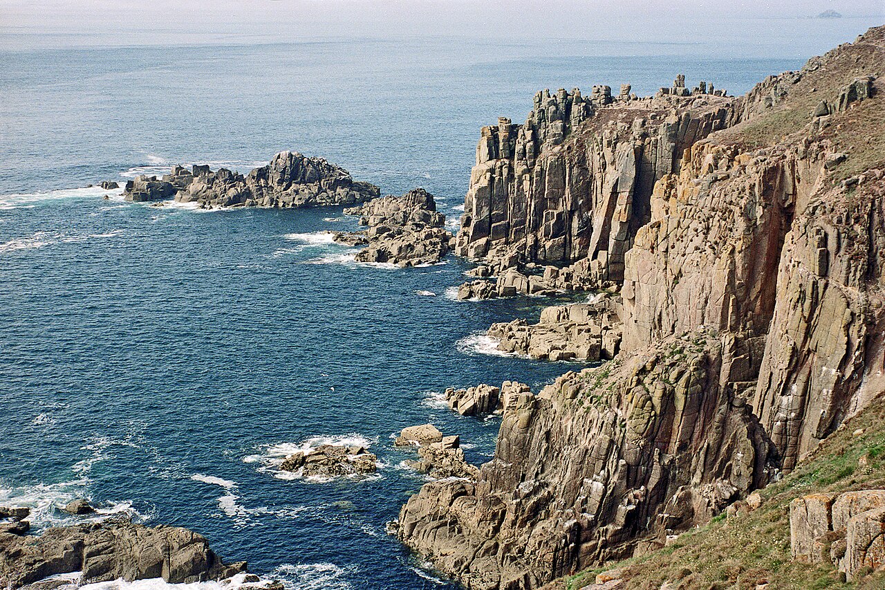
A peninsula shaped by granite
The far west of Cornwall has a landscape unlike much of the rest of the county. Around Land's End and across the central spine of Penwith, exposed rock, thin soils, open moorland and rugged cliffs reflect the influence of a large body of granite beneath the surface.
The Land's End Granite formed from molten rock that cooled slowly underground during the late stages of geological mountain-building in south-west Britain, about 275 to 280 million years ago – making it one of the youngest of the granite masses that rise from the Cornubian Batholith beneath Devon and Cornwall. As it cooled, minerals crystallised to create the coarse-grained rock that can be seen in many of the area's outcrops and coastal tors.
Granite is generally resistant to erosion, although joints and fractures allow weathering to break it down. Its exposed uplands contrast with surrounding areas where other rocks and deeper, more fertile soils have helped shape different patterns of farming and settlement.
Why does the landscape look so rugged?
Hard granite, fractured rock, thin upland soils and powerful Atlantic weather all contribute to Penwith's rocky ridges, dramatic headlands and uneven coastal scenery.
The rocks around the granite
The granite does not occur in isolation. Much of the surrounding countryside is formed from older sedimentary rocks, commonly described in Cornish mining terminology as killas, together with altered volcanic rocks. These rocks record ancient marine environments and volcanic activity long before the present coastline existed.
When the granite intruded into the surrounding rocks, its heat changed the rocks close to the contact. This process is known as contact metamorphism. Fluids released during the cooling and crystallisation of the granite also altered the chemistry of some rocks, a process called metasomatism.
The result is a varied geological zone around the granite margin, with rocks that may be harder, more crystalline or mineralogically different from those farther away. Geologists use the term metamorphic aureole for this zone of altered rock.
What are the “baked rocks”?
The expression “baked rocks” is a useful way to picture what happened when hot granite came into contact with older rocks. It is not ordinary surface burning: the transformation occurred underground, through intense heat and chemical reactions over geological time.
Around St Just and Botallack, some of the altered rocks include hornfels, a tough rock formed when existing rocks were recrystallised by heat – south of Botallack and at Kenidjack it contains large crystals of cordierite. Other altered rocks, called skarns, formed where hot fluids reacted with old volcanic greenstones, producing distinctive garnet-, amphibole- and magnetite-rich bands.
These changes matter because the contact zone helped create the geological conditions associated with some of West Cornwall's famous mineral deposits. The boundary between granite and country rock is therefore important both to the scenery and to the area's mining history.
The granite uplands of Penwith
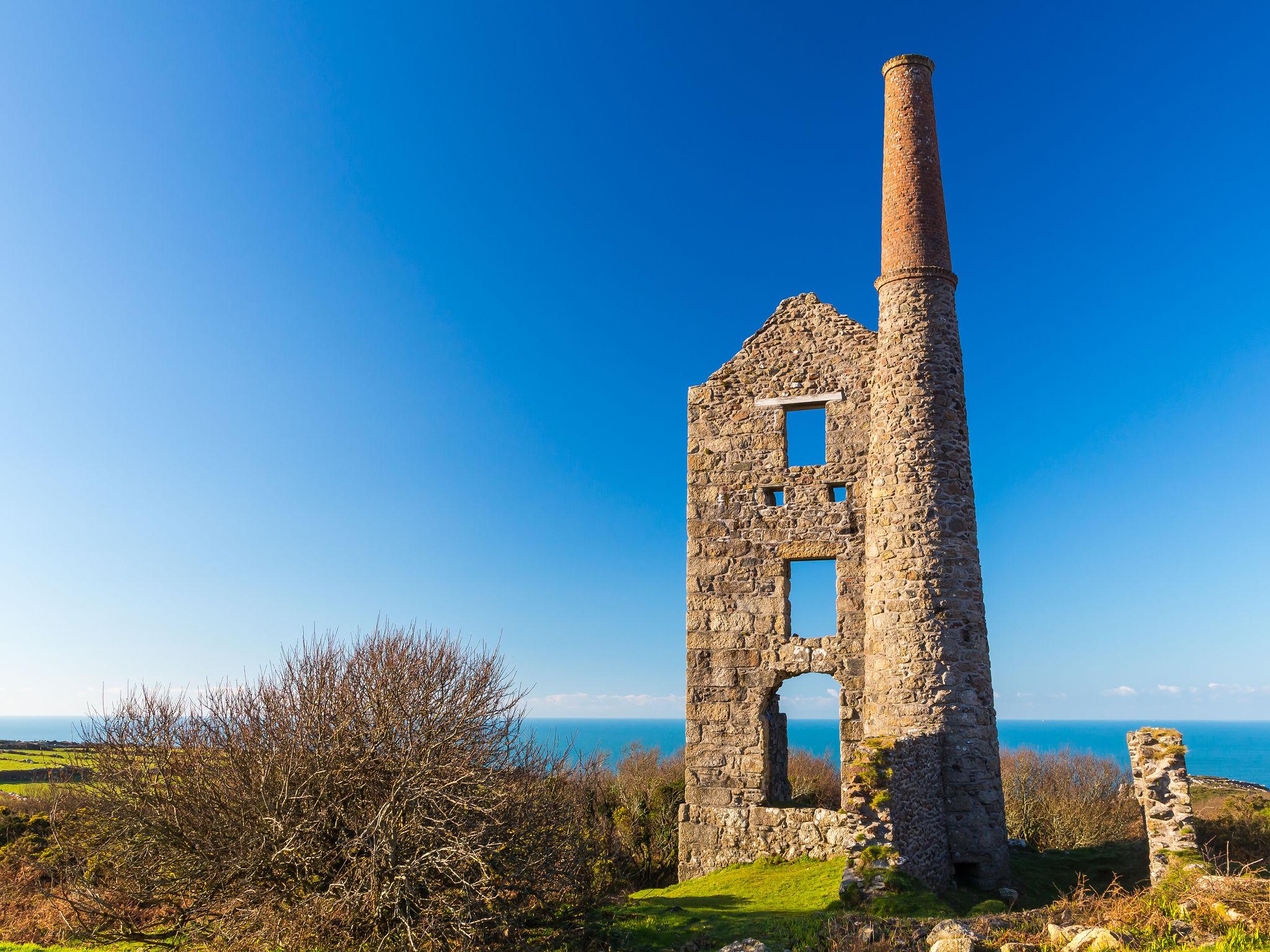
Carn Galver mine, between Zennor and St Just, stands on the granite moorland of the Penwith upland. Tin was worked here from at least the 17th century; the National Trust has cared for the engine houses since 1984.
The central granite ridge of Penwith rises above much of the surrounding land. Exposed rocky ground, low vegetation and shallow soils give parts of the uplands an open, windswept character.
Near the coast, granite is exposed in cliffs, ledges and uneven rock platforms. The sea exploits joints and fractures, gradually widening cracks and removing weakened material. Waves, salt, rain and repeated weathering all contribute to the changing coastline.
The granite is also a reminder that the present landscape is only the latest chapter in a long geological history. The rocks formed deep below an ancient land surface and were exposed much later by uplift, erosion and the removal of overlying material.
Mineral veins and the mining landscape
As the granite cooled, hot mineral-rich fluids moved through fractures in the granite and surrounding rocks. Minerals crystallised from these fluids, filling cracks to form veins or lodes. Some of these deposits contained economically valuable quantities of tin and copper, along with other minerals.
The distribution of minerals was not uniform. Around the Botallack district the tin–copper lodes cross the boundary between the granite and the country rock near the coast: copper was mainly worked in the metamorphosed rocks on the coast, while tin was mainly found farther inland in the granite. Botallack is even the type locality of a mineral – botallackite, a rare blue-green copper chloride first described here. The exact minerals varied from one lode and rock type to another.
Mining followed these deposits underground, sometimes extending far beneath the seabed. The remains of shafts, spoil heaps, dressing floors, chimneys and engine houses show how thoroughly the industry transformed the landscape.
From geology to industry
The granite provided heat and mineralising fluids; fractures and altered country rocks helped create places where ore minerals could accumulate. These geological conditions contributed to the growth of the St Just mining district.
Botallack Mine and the Crowns
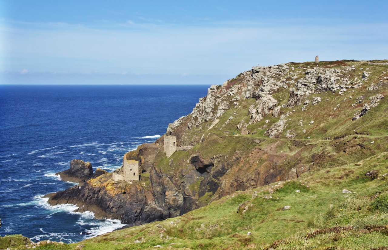
The Crowns engine houses at Botallack are among the most recognisable features of Cornwall's mining coast.
Botallack, near St Just, is one of the best-known places to see the relationship between West Cornwall's geology and its industrial past. The Crowns engine houses occupy a dramatic position on the cliffside above the Atlantic.
The mine's workings extended beneath the sea: the Boscawen Diagonal Shaft, sunk at an angle from the Crowns, ran out under the seabed. In 1865 the Prince and Princess of Wales descended it, setting off a brief fashion for visitor trips into the mine. Pumping engines helped remove water from underground workings, while winding engines raised and lowered people and materials. The steep terrain and the location of the ore deposits made engineering particularly challenging.
The buildings are not simply picturesque ruins. Their position reflects the practical demands of mining where mineral veins continued beneath difficult ground and, in places, below the seabed.
Falling tin and copper prices forced Botallack to close in 1895. Today the remains are cared for by the National Trust and form part of the Cornwall and West Devon Mining Landscape World Heritage Site.
Levant Mine and the Tin Coast
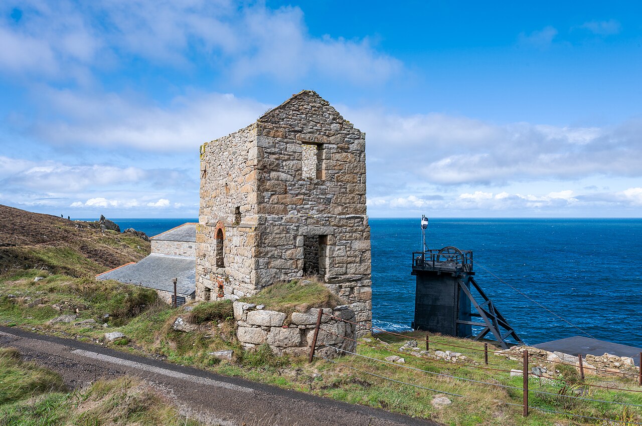
Further along the coast, Levant Mine is another important part of the Penwith mining story. Worked from 1820 to 1930, it became known as “the mine under the sea”: its tunnels ran up to about 2.5 km out from the cliffs and reached around 600 m deep. In 1919 the failure of its man engine – the moving ladder that carried miners up and down the shaft – killed 31 men.
Engine houses accommodated steam machinery used in the demanding work of pumping and winding. Levant’s beam engine, built around 1840 by Harvey’s of Hayle, is the oldest Cornish steam winding engine still working in its original position. Their survival offers a glimpse of the infrastructure required to exploit deposits in a landscape of steep slopes, exposed cliffs and hard rock.
The coast around St Just and Pendeen is especially valuable for understanding the relationship between mineralised rocks, mining technology and the lives of the communities that depended on the industry. Next door, Geevor Tin Mine is now a mining museum.
The rocks beneath the mining remains
Granite and country rock
Granite and the surrounding altered rocks together form a varied landscape of uplands, ridges and rugged coastal ground.
Mineralised coast
The coastal mining district preserves evidence of mineral veins, deep workings and the machinery used to reach them.
A changing coastline
Waves and weather exploit cracks and weaknesses in the rock, gradually shaping cliffs, gullies and offshore rock stacks.
How geology shaped West Cornwall
The distinctive character of Penwith is the result of several connected processes. Granite helped create a resistant upland spine; heat altered the surrounding rocks; mineralising fluids formed veins; and the Atlantic gradually sculpted the exposed coastline.
Human activity added another layer. Centuries of mining left engine houses, shafts, spoil heaps and other industrial remains across the peninsula. In places, these structures stand beside ancient field boundaries, small settlements and agricultural land, creating a landscape in which geology and human history are closely linked.
Around Land's End, St Just, Botallack and Pendeen, the scenery can therefore be read as a geological story: deep-seated granite, altered country rocks, mineral deposits, coastal erosion and the legacy of mining all contribute to the landscape seen today.
West Cornwall & Penwith Geology FAQ
Land’s End and the spine of the Penwith peninsula are made of the Land’s End Granite, part of the Cornubian Batholith that runs beneath Devon and Cornwall. It crystallised about 275 to 280 million years ago, making it one of the youngest of the Cornish granites.
When the hot granite pushed into the older slates and volcanic greenstones around it, its heat recrystallised them into hard hornfels. Hot fluids from the granite also changed their chemistry, producing skarns rich in garnet, amphibole and magnetite. This altered zone around the granite is called the metamorphic aureole.
As the granite cooled, hot fluids deposited tin and copper ores in fractures called lodes. Around Botallack these lodes cross the boundary between the granite and the baked rocks near the coast – tin mainly inland in the granite, copper mainly in the metamorphic rocks on the coast – so mines clustered along the cliffs.
Yes. At Botallack the Boscawen Diagonal Shaft ran out under the seabed, and Levant Mine’s tunnels reached up to about 2.5 km out from the cliffs and around 600 m deep, earning it the name ‘the mine under the sea’.
Botallack closed in 1895 after tin and copper prices fell. Levant worked from 1820 until 1930; in 1919 a failure of its man engine killed 31 miners. Neighbouring Geevor Tin Mine is now a mining museum.
Yes. The National Trust looks after the Crowns at Botallack, the Carn Galver engine houses between Zennor and St Just, and Levant Mine, where the 1840s beam engine – the oldest Cornish steam winding engine still working in its original position – is run on selected days. Check the National Trust website for opening times.
Yes – botallackite, a rare blue-green copper mineral, was first described from Botallack, which is its type locality. The St Just coast is famous among mineral collectors, but please don’t hammer or collect from the protected cliffs and mine sites.
Yes. The St Just Mining District, including Botallack and Levant, is part of the Cornwall and West Devon Mining Landscape World Heritage Site, inscribed by UNESCO in 2006.
Further reading and geological resources
Historic England (Research Report 160/2020)
Read about the landscape character of West Penwith, including its granite uplands, surrounding rocks and mineral veins.
West Penwith, Upland and Upland FringeGeoGuide (Geological Conservation Review)
Detailed geological information about Botallack, Wheal Owles, contact metamorphism and the mineralised rocks of the Tin Coast.
Botallack Mine and Wheal Owles geologyCornwall and West Devon Mining Landscape
Explore the wider industrial heritage of Cornwall's historic mining districts.
UNESCO World Heritage SiteBritish Geological Survey
Explore geological mapping and the distribution of rocks across Cornwall.
BGS Geology Viewer