Back to English Heritage Cornwall
St Breock Downs, Rosenannon, Cornwall PL30 5PN | 0370 333 1181
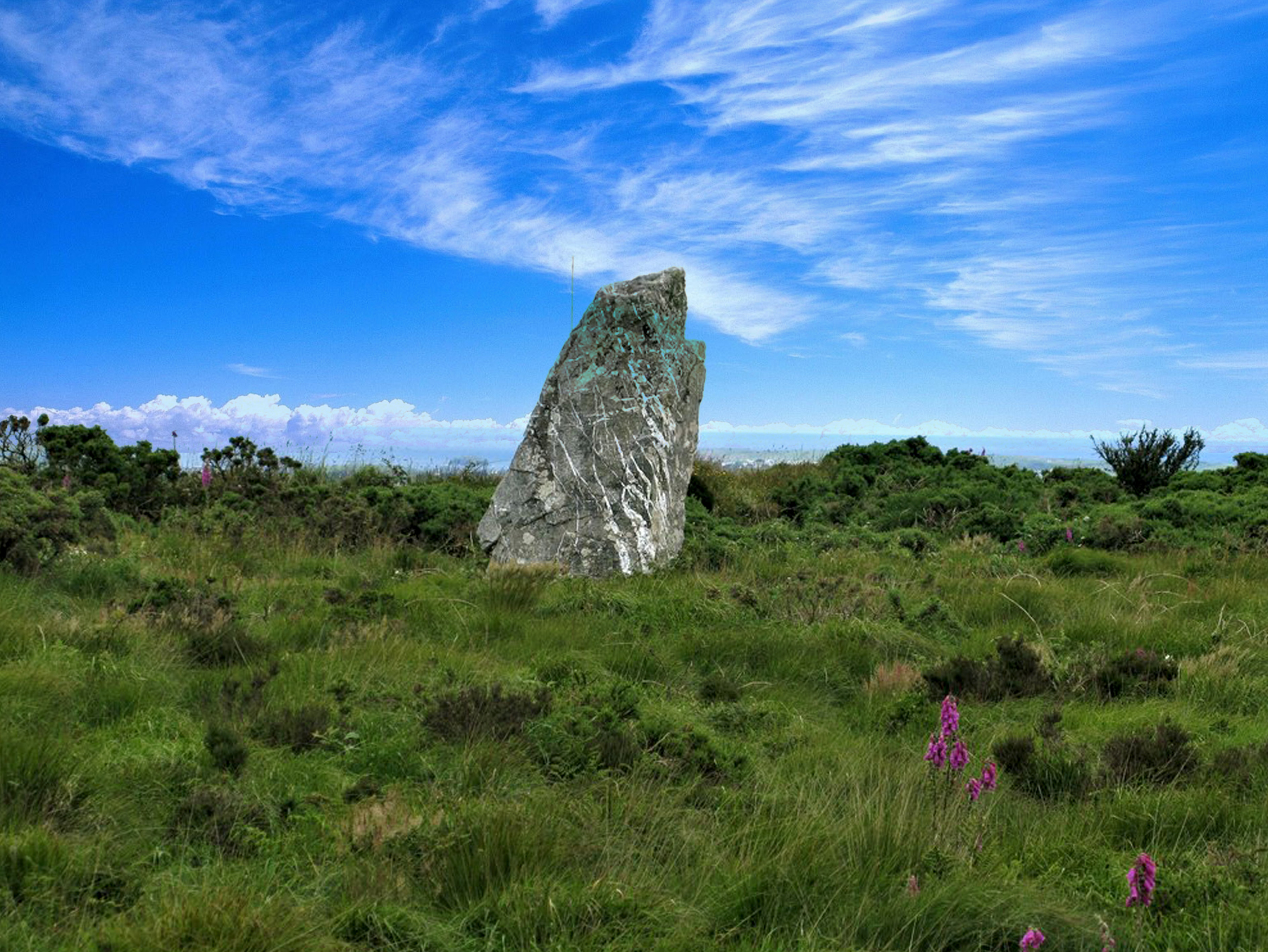
Standing alone on the exposed summit of St Breock Downs, a few miles south-west of Wadebridge, this weathered granite monolith is the largest and heaviest prehistoric standing stone anywhere in Cornwall. Weighing an estimated 16.75 tonnes, it has dominated this stretch of high, open moorland for around four thousand years, a solitary landmark visible for miles across the surrounding countryside.
The stone dates to the late Neolithic or mid-Bronze Age, somewhere between 2500 and 1500 BC, and originally measured close to 4.9 metres in length. It now stands just over 3 metres above the surrounding cairn, its pronounced northward tilt the result of a partial collapse and later re-erection rather than any change in the stone's true size. Local names for the monolith, including "Men Gurta" and the "St Breock Longstone", reflect centuries of continued local awareness of the stone as a landmark long after its original ceremonial purpose was forgotten.
Like many of Cornwall's Bronze Age standing stones, the monolith likely formed part of a wider ritual landscape rather than standing in true isolation. Further standing stones and burial barrows are recorded across St Breock Downs and the high ground extending westward for several miles, suggesting the summit here held special significance for the farming communities of prehistoric Cornwall over many centuries.
The monolith is owned by English Heritage and cared for day-to-day by the Cornwall Heritage Trust, and remains free to visit throughout the year. Its wild, elevated setting, with sweeping views across north Cornwall towards Bodmin Moor and the coast, makes the short walk from the roadside layby a rewarding one regardless of the weather.
Location Map
Visitor Guide
The monolith stands around two miles south-west of the village of Burlawn, on the high ground of St Breock Downs towards Rosenannon, and is marked from the road by a finger post. A layby provides parking a short distance from the path leading up to the stone, from which visitors cross open downland on foot to reach the monument.
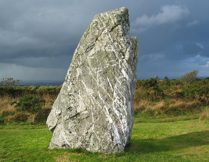
There is no marked path across the downs, so the ground underfoot is uneven, tussocky grassland that can be wet after rain, and sturdy footwear is strongly recommended. Once at the stone, its scale becomes clear at close quarters: the low cairn on which it sits, the visible tilt caused by its 1815 collapse and 1956 re-erection, and the sweeping, largely uninterrupted views across the surrounding farmland towards Bodmin Moor to the south-east and the north Cornwall coast beyond Wadebridge.
A visit need only take twenty to thirty minutes, though the exposed, open setting rewards those who linger to take in the views. There are no facilities at the site itself; the nearest full range of shops, cafes and restaurants is in Wadebridge, a short drive to the north-east, with Tintagel Castle within easy reach for visitors continuing along the north Cornwall coast.
History
The St Breock Downs Monolith is Cornwall's largest and heaviest surviving prehistoric standing stone, dating to the late Neolithic or mid-Bronze Age, roughly 2500 to 1500 BC. Formed from local Devonian shale with distinctive feldspar veining, the stone originally measured around 4.9 metres in length and was raised within a low cairn approximately 10 metres across, a considerable feat of prehistoric engineering given the stone's estimated weight of 16.75 tonnes.
The monolith fell in 1815, likely as a result of the soft ground beneath it giving way over time, and lay recumbent on the downs for well over a century before being re-erected in 1956. That excavation and re-erection revealed a setting of quartz pebbles beneath the stone, below which lay two small, shallow hollows — features that at comparable prehistoric sites elsewhere have been found to contain human remains or cremated bone, though no such remains were recovered here. The stone's current pronounced tilt reflects the practical realities of that 1956 re-erection rather than its original prehistoric alignment.
Standing stones of this kind are generally understood to have served ceremonial or ritual functions for the Bronze Age communities who raised them, though their precise meaning is impossible to recover with certainty. St Breock Downs Monolith does not stand in isolation: the surrounding high ground carries further standing stones and burial barrows extending westward for several miles, suggesting this elevated summit formed part of a broader prehistoric ritual landscape used and maintained over many generations. Some archaeologists have suggested that such large, solitary monoliths may have served as territorial or navigational markers within the landscape, visible for great distances and helping to define the boundaries of land used by different prehistoric communities.
The stone's prominence as a landmark long outlasted its original ceremonial purpose. It appears in antiquarian records dating back to 1613, and was later adopted as a boundary marker for the parish of St Breock, acquiring the alternative names "St Breock Longstone" and "Men Gurta" along the way. This continued practical use across the centuries, from prehistoric monument to medieval and modern parish marker, is a reminder of how enduring and adaptable Cornwall's oldest monuments have proved to be, remaining meaningful landmarks in the landscape long after the beliefs that first raised them had faded from memory.
Today the monolith is owned by English Heritage and managed on a day-to-day basis by the Cornwall Heritage Trust, which cares for a number of similar prehistoric sites across Cornwall on English Heritage's behalf. It remains freely accessible to visitors throughout the year on the open downland where it has stood for around four thousand years, one of the most striking and least-visited of Cornwall's great prehistoric monuments.
Important Features
- The monolith itself: Cornwall's largest and heaviest prehistoric standing stone, weighing an estimated 16.75 tonnes.
- The surrounding cairn: a low mound of local shale approximately 10 metres across on which the stone stands.
- The 1956 re-erection: excavation revealing quartz pebbles and two shallow hollows beneath the fallen stone.
- Wider prehistoric landscape: further standing stones and Bronze Age barrows recorded across St Breock Downs.
- Parish boundary marker: the stone's later role marking the boundary of St Breock parish.
- Panoramic views: sweeping outlooks across north Cornwall from the exposed downland summit.
Visitor Information
Parking
A layby a short distance from the footpath to the monolith. No dedicated car park at the site.
Facilities
None at the site. Wadebridge, a short drive away, has a full range of shops, cafes and restaurants.
Disabled Access
Limited. The stone is reached across open, uneven downland with no formal path or step-free surface.
- Opening times: open any reasonable time during daylight hours, year-round.
- Public transport: very limited; the nearest bus services run to Wadebridge, several miles away.
- Toilets: none at the site; facilities are available in Wadebridge.
- Food and drink: none on site; Wadebridge offers a wide choice of cafes and restaurants.
- Shop: no shop on site.
- Dogs: welcome on leads.
- Booking: not required — free entry, no ticketing.
- Family facilities: none on site; the exposed, uneven downland is unsuitable for pushchairs.
- Additional access: smoking, vaping, barbecues and naked flames are not permitted.
- Visit duration: around twenty to thirty minutes.
Things to Do Nearby
Tintagel Castle
Tintagel
The legendary clifftop stronghold linked to the story of King Arthur, one of Cornwall's most spectacular sites.
Find Out MoreWadebridge
Nearest town
A bustling market town on the Camel Estuary with shops, restaurants and the Camel Trail cycle route.
Find Out MorePadstow
Camel Estuary
A famous harbour town known for its seafood restaurants, boat trips and coastal walks.
Find Out MoreBodmin
Cornwall's county town
A historic town on the edge of Bodmin Moor, with shops, museums and easy access to the moor's prehistoric sites.
Find Out MoreRock
Camel Estuary
A popular sailing and watersports village across the estuary from Padstow, with sandy beaches nearby.
Find Out MoreFrequently Asked Questions
Official English Heritage Site
For the latest access information, events and any temporary restrictions, check the official English Heritage page for St Breock Downs Monolith before you travel.
Explore More Cornwall Heritage
All English Heritage Sites Cornwall Attractions National Trust Cornwall
Page last updated: 25 August 2026.