
 MINIONS
- BODMIN MOOR
MINIONS
- BODMIN MOOR
A
circular walk south from Minions, around Caradon Hill, with panoramic
views, taking in a fine selection of Industrial Archaeology.
| Distance: | 4 miles. 2 hours | Recommended
maps: Ordnance Survey Explorer Map 109 |
|
| Grade: | Easy Track, footpath, open grazing |
||
| Facilities: | Public toilets, cafés, pub and store in the village. | ||
| Parking: |
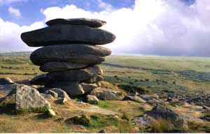
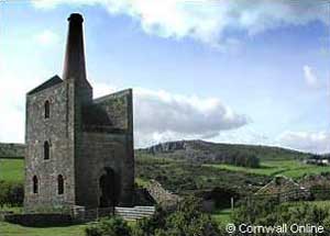
Free and plentiful, next to the Heritage Centre. Parking is close to the Hurlers, a Neolithic stone circle and also a good starting point for exploring the Cheesewring - a granite tor to the north of Minions. The Heritage Centre, a restored engine house close to the car park with disabled access is well worth a visit (free).
|
||
 |
 |
 |
 |
|
All information given in good faith and for use as guidance only. |
 |
![]()
Leave Minions village heading towards Caradon Mast on a tarmac track adjacent to the village stores. No need to stay on this track for long. To your left are a few disused engine houses. Make across the open fields, through a gap in the field boundary to the further of the engine houses. You are looking for a disused tramway, which will be your path around Caradon Hill.
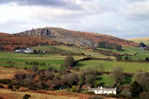
Turn right along the tramway (an ideal mountain bike track and soak in the views of Bodmin Moor - the granite tors, the Cheesewring, perched above the quarry and Sharp Tor outlined above the tiny village of Henwood. As you walk east, Kit Hill, a mining stack on its summit, comes into view. Sheltered on its southern slopes is the sleepy, once mining/market town of Callington.
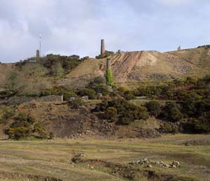
As the tram way sweeps around to the south, above the village of Upton Cross (the home of Sterts Amphiheatre) you find yourself on the edge of a mound of granite mine-waste. Continue south for about 1 km (0.6 miles) until the tramway runs close to the road. Follow the tramway keeping the spoil heap to your right. Soon a lodge style hotel will appear on your right.
To the left of the hotel is a stone wall. Follow the wall upwards towards the mast but when the opportunity arises cross over to its left. In the distance look out for Plymouth Harbour, Looe Bay and the china clay heaps of St Austell.
Follow the wall nearly to the top and change course only when you see a huge pile of quarried boulders to your left. This is the start of a journey into the history of Cornish tin mining. Make towards the boulders and the shelter of the old granite quarry would make a good picnic spot.
From the mouth of the quarry, follow an unmarked footpath to the left, the south, away from the mast. At this point the whole of Gonamena valley comes into view.
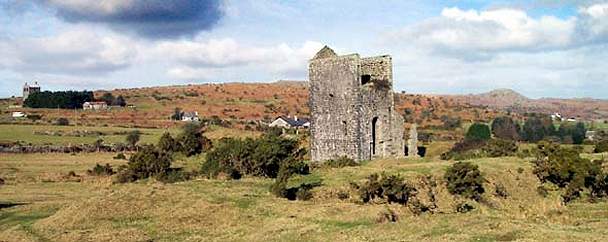
Make your way, south south west, towards the ruined chimneys above the valley bottom (South Caradon mine - as featured in BBC2's "Restoration" programme) and towards the village of St. Cleer in the distance. Engine houses, a power harnessed to haul cages carrying ore deep out of the mines, to pump water from the otherwise flooded mines or to drive the bellows of the blast furnace. Follow the track down between these engine houses. At the next junction turn right and follow what is now a wide rough track down to the valley floor.
A wide valley floor, cobbled in places where the women or 'bal maidens' broke up the tin ore by hand using hammers. Later the ore was 'stamped', Stamps were iron weight held in a framework of vertical wooded poles that were driven up and down by a water wheel steam engine. The crushed ore was then heated, just to above the melting point of tin, in a blast furnace. The tin melted and was cast into granite moulds.
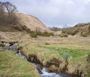
The next section to this walk follows this stream, the headwaters of the River Seaton, back to its source. It's tempting to cross the wooden bridge and follow the path on the left hand side of the valley. It's easier stick to the right hand bank.
Make for the picturesque medieval farmhouse of Gonamena from where you pick up a signed footpath, which at times is unclear but keep heading straight on, at one junction into a cutting and under the solitary remains of a tramway. Pass through a new metal gate. You are nearly back at Minions. Just look out for a marshy area and derelict cottages to your right, the source of the River Seaton.

LOCAL GUIDES MAPS AND BOOKS